

- Usage in publication:
-
- Red Desert tongue*
- Modifications:
-
- Original reference
- Dominant lithology:
-
- Coal
- Shale
- Siltstone
- Sandstone
- Oil-shale
- AAPG geologic province:
-
- Green River basin
Summary:
Pg. 100, 101 (chart). Red Desert tongue of Wasatch formation. Sequence of coal beds, clay shale, siltstone, biotitic sandstone, and low-grade oil shale. Upper 400 feet contains many coal beds including Creston and Tierney coal zones. Only upper 400 feet of tongue exposed in central part of Great Divide basin, but similar rocks on east flank of Rock Springs uplift are about 1,000 feet thick. Underlies Luman tongue (new) of Green River formation; unconformably overlies Fort Union formation. Intertongues with Battle Spring formation (new) to the north. Age is early Eocene.
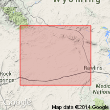
Named from exposures southwest of Red Desert Flat at Tipton Buttes and northeast of Red Desert Flat in NW corner T. 21 N., R. 94 W., and adjoining parts of T. 21 N., R. 95 W., T. 22 N., R. 94 W., and T. 22 N., R. 95 W., Sweetwater Co., southwestern WY.
Source: US geologic names lexicon (USGS Bull. 1200, p. 3219).
For more information, please contact Nancy Stamm, Geologic Names Committee Secretary.
Asterisk (*) indicates published by U.S. Geological Survey authors.
"No current usage" (†) implies that a name has been abandoned or has fallen into disuse. Former usage and, if known, replacement name given in parentheses ( ).
Slash (/) indicates name conflicts with nomenclatural guidelines (CSN, 1933; ACSN, 1961, 1970; NACSN, 1983, 2005, 2021). May be explained within brackets ([ ]).