The National Geologic Map Database is migrating to a new infrastructure. We apologize for any service disruptions during this process.
|
|---|


- Usage in publication:
-
- Red Bridge limestone
- Modifications:
-
- Named
- Dominant lithology:
-
- Limestone
- AAPG geologic province:
-
- Cincinnati arch
Summary:
Name Red Bridge limestone applied to reddish-yellow impure argillaceous limestone, 6 in. to 6 ft thick that overlies Mississinewa shale and underlies Liston Creek limestone where it crops out along Mississinewa River at village of Red Bridge, Wabash Co., and elsewhere. No fossils found. Included in Niagaran.
Source: GNU records (USGS DDS-6; Reston GNULEX).
- Usage in publication:
-
- Red Bridge limestone member
- Modifications:
-
- Revised
- AAPG geologic province:
-
- Cincinnati arch
Summary:
Liston Creek formation, as here defined consists of the strata lying conformably between top of Mississinewa shale and base of overlying Huntington dolomite. Formation consists of Red Bridge limestone member, a local bed (0 to 12 t thick) at base, and the Liston Creek limestone (up to 60 ft thick) at top. Where Red Bridge limestone member thins out there is no evidence of disconformity between Liston Creek limestone member and underlying Mississinewa shale. No fossils yet identified. Authors doubt that any of the geologist who have worked in northern IN have ever recognized this bed, for there has been no mention of it in the literature. It has been seen in Wabash Co. only and probably was not deposited elsewhere. Age is Silurian (Niagaran).
Source: GNU records (USGS DDS-6; Reston GNULEX).

- Usage in publication:
-
- Red Bridge Limestone Bed
- Modifications:
-
- Overview
- AAPG geologic province:
-
- Cincinnati arch
Summary:
Red Bridge was reduced in rank to Bed in Liston Creek Limestone Member of Wabash Formation by Pinsak and Shaver (1964) and that usage is adopted by the Indiana Geological Survey.
Source: GNU records (USGS DDS-6; Reston GNULEX).

- Usage in publication:
-
- Red Bridge Limestone Bed
- Modifications:
-
- Overview
- AAPG geologic province:
-
- Cincinnati arch
Summary:
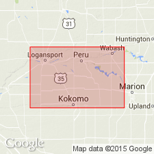
Type section in the bluff of the Mississinewa River is now under water during at least part of the year, but good exposures remain along the Wabash River in western Wabash Co. One of these is in the IN 13 and 15 road cuts in the south bluff south of Wabash (north-central part of sec. 18, T27N, R6E) where the 1.4 ft Red Bridge overlies a 48 ft section of the Mississinewa Shale Member of the Wabash. Another good section flanks the Shanty Falls Reef, 1 mi west of Wabash. The name has had little or no use outside Wabash Co., although glauconite is found in the lower Liston Creek rocks in Howard Co.
Source: GNU records (USGS DDS-6; Reston GNULEX).
For more information, please contact Nancy Stamm, Geologic Names Committee Secretary.
Asterisk (*) indicates published by U.S. Geological Survey authors.
"No current usage" (†) implies that a name has been abandoned or has fallen into disuse. Former usage and, if known, replacement name given in parentheses ( ).
Slash (/) indicates name conflicts with nomenclatural guidelines (CSN, 1933; ACSN, 1961, 1970; NACSN, 1983, 2005, 2021). May be explained within brackets ([ ]).