

- Usage in publication:
-
- Red Branch member*
- Modifications:
-
- Original reference
- Dominant lithology:
-
- Sandstone
- Shale
- Lignite
- AAPG geologic province:
-
- Fort Worth syncline
- Ouachita folded belt
- South Oklahoma folded belt
Summary:
Red Branch Member of Woodbine Formation. Described at its type locality as consisting of tuffaceous sandstone, carbonaceous shale, and lignite; elsewhere includes sandy shale and ferruginous sandstone, entire sequence being from 50 to 80 feet thick. Overlies Dexter member; downdip grades into material indistinguishable from overlying Lewisville and is classed with that member. Hill (1901) included these rocks in his Dexter sands and Lewisville beds. Fossils. Age is Late Cretaceous.
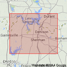
Type locality: near the Red Branch community in northwestern Grayson Co., northeastern TX. Recognized notably in Fannin, Grayson, and eastern Cooke Cos., northeastern TX.
Source: Publication; US geologic names lexicon (USGS Bull. 1200, p. 3217).
- Usage in publication:
-
- Red Branch member*
- Modifications:
-
- Areal extent
- AAPG geologic province:
-
- Ouachita folded belt
Summary:
Pg. 240-244. Red Branch member of Woodbine formation. Geographically extended into Bryan County, southwestern Oklahoma.
Source: Publication; US geologic names lexicon (USGS Bull. 1200, p. 3217).

- Usage in publication:
-
- Red Branch Member
- Modifications:
-
- Mapped 1:250k
- Dominant lithology:
-
- Sandstone
- Shale
- Lignite
- AAPG geologic province:
-
- Ouachita folded belt
- South Oklahoma folded belt
Summary:
Pamphlet [p. 4]. Red Branch Member of Woodbine Formation. In Texas, sandstone, shale, and lignite; sandstone, tuffaceous, in part ferruginous; shale, gray, brown, yellowish-brown, grayish-black, carbonaceous, in part sandy; thickness 25 to 80 feet, southward indistinguishable from Lewisville Member. In Oklahoma, sandstone, shale, and lignite; sandstone is in part ferruginous and tuffaceous; shale, gray, brown, yellowish-brown to black, contains several lignite and thin coal beds, thin-bedded and platy siltstone beds in upper part; thickness 60 to 70 feet. Lies above Dexter Member and below Lewisville Member; both of Woodbine Formation. Age is Late Cretaceous.
[Mapped on either side of Red River and southward to Lake Ray Roberts (Tioga area); in Cooke, Fannin, and Grayson Cos., northeastern TX, and Bryan Co., southeastern OK; northeastern and central part of map sheet.]
Source: Publication.
For more information, please contact Nancy Stamm, Geologic Names Committee Secretary.
Asterisk (*) indicates published by U.S. Geological Survey authors.
"No current usage" (†) implies that a name has been abandoned or has fallen into disuse. Former usage and, if known, replacement name given in parentheses ( ).
Slash (/) indicates name conflicts with nomenclatural guidelines (CSN, 1933; ACSN, 1961, 1970; NACSN, 1983, 2005, 2021). May be explained within brackets ([ ]).