The National Geologic Map Database is migrating to a new infrastructure. We apologize for any service disruptions during this process.
|
|---|


- Usage in publication:
-
- Rawley andesite*
- Modifications:
-
- Named
- Dominant lithology:
-
- Andesite
- AAPG geologic province:
-
- San Luis basin
Summary:
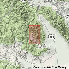
Named for occurrence on slopes of Rawley Gulch and in Rawley mine, Saguache Co, CO in San Luis basin. Consists of thick series of flows and breccias which range in composition between augite, andesite and latite. Individual flows range from 10-15 ft to 100+ ft thick, totaling 1200 to 2000 ft thick. Overlies pre-Cambrian rocks in northern part of district; overlies Paleozoic sedimentary rocks in southern part of district. Underlies Bonanza latite in northern part of district; underlies Hayden Peak latite in southern part of district. Is a widespread map unit in the east and central parts of the geologic map. Is of Tertiary age.
Source: GNU records (USGS DDS-6; Denver GNULEX).
For more information, please contact Nancy Stamm, Geologic Names Committee Secretary.
Asterisk (*) indicates published by U.S. Geological Survey authors.
"No current usage" (†) implies that a name has been abandoned or has fallen into disuse. Former usage and, if known, replacement name given in parentheses ( ).
Slash (/) indicates name conflicts with nomenclatural guidelines (CSN, 1933; ACSN, 1961, 1970; NACSN, 1983, 2005, 2021). May be explained within brackets ([ ]).