The National Geologic Map Database is migrating to a new infrastructure. We apologize for any service disruptions during this process.
|
|---|


- Usage in publication:
-
- Rattler Granodiorite*
- Modifications:
-
- Named
- Geochronologic dating
- Dominant lithology:
-
- Quartz diorite
- AAPG geologic province:
-
- Basin-and-Range province
Summary:
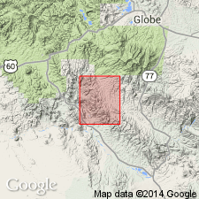
Named for exposures at Rattler mine, sec 26, T3S, R14E, its type locality, Pinal Co, AZ in Basin-and-Range province. Ranges from quartz diorite to sodic granite aplite. Main type is granodiorite, granitic in texture, and in composition except that hornblende and biotite vary. Is a pear shaped stock. Cuts Paleozoic sedimentary rocks. Is cut by many of the Laramide dikes. K-Ar age determinations give an age of 70 +/-2 m.y. for biotite and 74 +/-2 m.y. for hornblende. Geologic map.
Source: GNU records (USGS DDS-6; Denver GNULEX).
For more information, please contact Nancy Stamm, Geologic Names Committee Secretary.
Asterisk (*) indicates published by U.S. Geological Survey authors.
"No current usage" (†) implies that a name has been abandoned or has fallen into disuse. Former usage and, if known, replacement name given in parentheses ( ).
Slash (/) indicates name conflicts with nomenclatural guidelines (CSN, 1933; ACSN, 1961, 1970; NACSN, 1983, 2005, 2021). May be explained within brackets ([ ]).