- Usage in publication:
-
- Rathbun limestone member
- Modifications:
-
- Named
- Dominant lithology:
-
- Limestone
- AAPG geologic province:
-
- Appalachian basin
Summary:
Name Rathbun Limestone member proposed for basal member of Denmark formation. Described at type section as brachiopod coquina, calcilutite, and calcareous shale. Contrasts with underlying Shorham limestone by abundance of calcilutite; contrasts sharply with overlying Poland limestone member (new) by presence of coquina beds. Lithologically more similar to Shoreham than to Poland, but arbitrarily placed in Denmark formation because persistent basal calcarenite suggests subjacent disconformity. Maximum thickness 10 ft; 6 ft at type section. Persists along West Canada Creek but thins southeastward and is absent to the east at Little Falls. Age is Middle Ordovician (Mohawkian).
Source: GNU records (USGS DDS-6; Reston GNULEX).

- Usage in publication:
-
- Rathbun Member
- Modifications:
-
- Overview
- Areal extent
- AAPG geologic province:
-
- Appalachian basin
Summary:
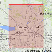
Rathbun Member of Sugar River Limestone in central NY includes massive, ledge-forming, packstones and grainstones with few, thin shale interbeds. Unit overlies Sugar River wacke- to packstones and underlies City Brook bed (new informal name) of Poland Member (Denley Limestone). The Rathbun is 2 m thick at its type locality and can be traced southeastward to the Little Falls area and northwestward to Gravesville. Sugar River strata, correlative with the Rathbun, crop out in numerous stream sections in the Lowville area (66 km northwest of Gravesville). Southeast of Little Falls, the Rathbun is absent, probably removed by erosion.
Source: GNU records (USGS DDS-6; Reston GNULEX).
For more information, please contact Nancy Stamm, Geologic Names Committee Secretary.
Asterisk (*) indicates published by U.S. Geological Survey authors.
"No current usage" (†) implies that a name has been abandoned or has fallen into disuse. Former usage and, if known, replacement name given in parentheses ( ).
Slash (/) indicates name conflicts with nomenclatural guidelines (CSN, 1933; ACSN, 1961, 1970; NACSN, 1983, 2005, 2021). May be explained within brackets ([ ]).

