

- Usage in publication:
-
- Rancheria Gulch Sandstone Beds*
- Modifications:
-
- Named
- Biostratigraphic dating
- Dominant lithology:
-
- Sandstone
- Siltstone
- AAPG geologic province:
-
- Klamath Mountains province
Summary:
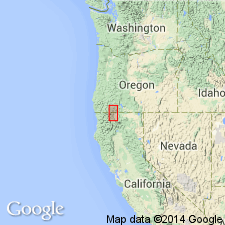
[Named] as part of Blue Gulch Mudstone Member (new) of Hornbrook Formation. Beds are located near Rancheria Gulch and crop out between Ditch Creek and Osburger Gulch, northwest-southeast distance of about 8 km. Consists of fine-grained gray sandstone with thin interbeds of siltstone near upper part. Is 85.8 m thick near Rancheria Gulch. Conformably overlies and underlies mudstone of Blue Gulch Mudstone Member. Age is Campanian based on molluscan fossils present in beds.
Source: GNU records (USGS DDS-6; Menlo GNULEX).
- Usage in publication:
-
- Rancheria Gulch Sandstone Beds*
- Modifications:
-
- Age modified
- Overview
- AAPG geologic province:
-
- Klamath Mountains province
Summary:
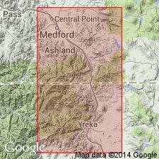
Ammonites and INOCERAMUS collected from upper part of Rancheria Gulch Sandstone Beds (Peck and others, 1956) and megafossils from lower, middle, and upper parts of unit (Sliter and others, 1984) suggest age to be late Campanian (about 79 to 75 Ma). Measured type section is designated as exposures southeast of Rancheria Gulch in center S/2 SW/4 sec.20 T47N R6W, Hornbrook 15' quad, Siskiyou Co, CA. Detailed lithology, list of fossils, depositional environment and mapping included in report.
Source: GNU records (USGS DDS-6; Menlo GNULEX).
For more information, please contact Nancy Stamm, Geologic Names Committee Secretary.
Asterisk (*) indicates published by U.S. Geological Survey authors.
"No current usage" (†) implies that a name has been abandoned or has fallen into disuse. Former usage and, if known, replacement name given in parentheses ( ).
Slash (/) indicates name conflicts with nomenclatural guidelines (CSN, 1933; ACSN, 1961, 1970; NACSN, 1983, 2005, 2021). May be explained within brackets ([ ]).