The National Geologic Map Database is migrating to a new infrastructure. We apologize for any service disruptions during this process.
|
|---|


- Usage in publication:
-
- Rainbow Gardens Member*
- Modifications:
-
- Named
- Dominant lithology:
-
- Conglomerate
- Sandstone
- Gypsum
- Limestone
- Dolomite
- AAPG geologic province:
-
- Great Basin province
- Plateau sedimentary province
Summary:
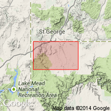
Named basal member of four members of Horse Spring Formation for exposures in Rainbow Gardens. Type section designated lat 36 deg 08' 30" N and long 114 deg 57' 30" W in Henderson and Frenchman Mountain quads, NV, Great Basin province. Divisible into 5 lithofacies. Mapped (distribution map) in scattered exposures north of Lake Mead in Clark Co, NV and into adjacent Mohave Co, AZ, Plateau sedimentary province. Thickness varies; 50 to 400 m thick. Resistant brown conglomerate--a pediment deposit--at base at every known exposure and in middle part; the clasts derived mostly from Kaibab and Toroweap Formations are small chiefly subangular to subround limestone and cherty limestone. Red and brown, chiefly medium-grained, rarely coarse-grained, rounded quartz sandstone, and some brown siltstone present in lower and middle parts. Nonresistant white claystone, green, black and white chert are interbedded with white, buff, gray, and brown limestone and dolomite, and arenaceous limestone and dolomite; these are the dominant lithologies. White, gray, pink gypsum predominant in some sections. Some tuffaceous beds. Graphic stratigraphic sections. Rocks above basal conglomerate deposited in lake, lakeshore, marginal lake, playa, spring and alluvial environment. Unconformably overlies rocks of Permian to Cretaceous age; underlies Thumb Member of Horse Spring. Has not been directly dated; thought to be no older than about 20 m.y. or Miocene.
Source: GNU records (USGS DDS-6; Denver GNULEX).
- Usage in publication:
-
- Rainbow Gardens Member*
- Modifications:
-
- Age modified
- Geochronologic dating
- AAPG geologic province:
-
- Great Basin province
Summary:
Age of the Rainbow Garden Member of the Horse Spring Formation in the southern Virgin Mountains is revised from Miocene to: late Oligocene to middle Miocene, based on age range of approximately 26 Ma to 18 Ma (radiometric age [K-Ar, biotite] of 24.3 Ma). Overall age thus revised from Miocene to: late Oligocene to middle Miocene.
Source: GNU records (USGS DDS-6; Menlo GNULEX).
- Usage in publication:
-
- Rainbow Gardens Member*
- Modifications:
-
- Mapped 1:100k
- AAPG geologic province:
-
- Plateau sedimentary province
Summary:
Rainbow Gardens Member of Horse Spring Formation. Named Cottonwood Wash Formation by Moore (Arizona Bur. Mines Bull., no. 186, 1972), but because these rocks have close lithologic and stratigraphic similarity to the Rainbow Gardens Member of the Horse Spring Formation, this usage is followed herein as used by Bohannon (USGS Prof. Paper 1259, 1984). Divided into (descending): (1) limestone unit, pale-brown, pinkish-white and light-gray, medium- to coarse-grained, thin- to medium-bedded, crystalline, cliff-forming limestone and intraformational limestone breccia, 75 to 100 m thick; (2) tuffaceous limestone and sandstone unit, green to white tuffaceous, cliff-forming limestone and crystalline limestone interbedded with green to light-brown, ledge-forming calcareous sandstone and tuffaceous sandstone and slope-forming white claystone, 50 to 100 m thick; and (3) conglomerate unit, brown and red-brown, cliff-forming, well-sorted, clast-supported conglomerate (clasts are subrounded to subangular cobbles and pebbles from 1 to 70 cm in diameter, matrix is sandy, calcareous), 3 to 50 m thick. Unconformably overlies Lower Cretaceous Willow Tank Formation. Nonmarine. Age is Miocene.
Notable exposures along southwestern edge of Littlefield quadrangle, south of Virgin Mountains and west of Cottonwood Wash, in T. 37 N., R. 15 and 16 W., Mohave Co., northwestern AZ.
Source: Publication.
For more information, please contact Nancy Stamm, Geologic Names Committee Secretary.
Asterisk (*) indicates published by U.S. Geological Survey authors.
"No current usage" (†) implies that a name has been abandoned or has fallen into disuse. Former usage and, if known, replacement name given in parentheses ( ).
Slash (/) indicates name conflicts with nomenclatural guidelines (CSN, 1933; ACSN, 1961, 1970; NACSN, 1983, 2005, 2021). May be explained within brackets ([ ]).