

- Usage in publication:
-
- Quilici Formation
- Modifications:
-
- Named
- AAPG geologic province:
-
- Great Basin province
Summary:
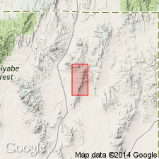
Pg. opp. 2692, 2693 (table 1), 2695 (fig. 6), 2699-2700. Quilici Formation. Ledge-forming unit present in the HD Range, northeastern Nevada. Consists of basal chert pebble conglomerate and upper limestone with siltstone and sandstone beds. Thickness 106 m. Unconformably overlies Agort Chert or Noh Formation; disconformably underlies Buckskin Mountain Formation. Age is Middle Pennsylvanian (Desmoinesian).
Type locality: west flank of range at base of cliff where Bloody Gulch turns to the northeast and 0.8 km south-southwest of Tiser Spring, Elko Co., northeastern NV.
Source: US geologic names lexicon (USGS Bull. 1520, p. 249-250); GNC index card files (USGS-Reston).
For more information, please contact Nancy Stamm, Geologic Names Committee Secretary.
Asterisk (*) indicates published by U.S. Geological Survey authors.
"No current usage" (†) implies that a name has been abandoned or has fallen into disuse. Former usage and, if known, replacement name given in parentheses ( ).
Slash (/) indicates name conflicts with nomenclatural guidelines (CSN, 1933; ACSN, 1961, 1970; NACSN, 1983, 2005, 2021). May be explained within brackets ([ ]).