The National Geologic Map Database is migrating to a new infrastructure. We apologize for any service disruptions during this process.
|
|---|


- Usage in publication:
-
- Pyle Mountain argillite
- Modifications:
-
- Named
- Dominant lithology:
-
- Argillite
- AAPG geologic province:
-
- New England province
Summary:
Pg. 16 (table 2), 20-22, pl. 1. Pyle Mountain argillite. Olive-colored argillite. To north unit becomes more calcareous and tends to be grayer in color. Average thickness, estimated from cross-section, about 600 feet. Appears to lie stratigraphically above unit Ovs, which includes rocks of same age as Ribbon Rock member of Meduxnekeag Formation in addition to older rocks. Underlies Frenchville Formation (new). Age is Late Ordovician.
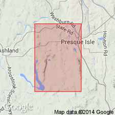
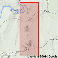
Type section: fossiliferous exposures along road extending across north slope of Pyle Mountain at intersection with Turner Road, Presque Isle quadrangle, northeastern ME.
Source: US geologic names lexicon (USGS Bull. 1350, p. 604).
- Usage in publication:
-
- Pyle Mountain Argillite
- Modifications:
-
- Biostratigraphic dating
- Overview
- AAPG geologic province:
-
- New England province
Summary:
Pyle Mountain Argillite is a part of the poorly known Upper Ordovician sedimentary and volcanic complex of the northeastern ME segment of the northern Appalachians. Unit consists of fine-grained, olive-green, noncalcareous argillite in southern exposures, becoming more calcareous and gray in northern exposures. It was mapped originally on opposite flanks of the Castle Hill anticline as a belt about 175 m wide above unnamed volcanic rocks (later referred to as Winterville Formation) and beneath shale (New Sweden Formation) and sandstone (Frenchville Formation) of probable Early Silurian age. The Pyle Mountain is very poorly exposed and is known from only 10 exposures. Neither boundary has been observed, but both are probably disconformable. FOLIOMENA FOLIUM (Barrande) and other very small, thin-shelled brachiopods from this unit in Aroostook Co. provide the only record of the presence of the FOLIOMENA fauna in North America. An Ashgillian age is established by the presence of graptolites of the CLIMACOGRAPTUS SPINIFEROUS Zone in the underlying Winterville Formation. The inferred late Ashgillian fossils of the Pyle Mountain indicate an environment of cool, deep waters.
Source: GNU records (USGS DDS-6; Reston GNULEX).
For more information, please contact Nancy Stamm, Geologic Names Committee Secretary.
Asterisk (*) indicates published by U.S. Geological Survey authors.
"No current usage" (†) implies that a name has been abandoned or has fallen into disuse. Former usage and, if known, replacement name given in parentheses ( ).
Slash (/) indicates name conflicts with nomenclatural guidelines (CSN, 1933; ACSN, 1961, 1970; NACSN, 1983, 2005, 2021). May be explained within brackets ([ ]).