The National Geologic Map Database is migrating to a new infrastructure. We apologize for any service disruptions during this process.
|
|---|


- Usage in publication:
-
- Putney Volcanics*
- Modifications:
-
- Overview
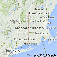
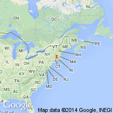
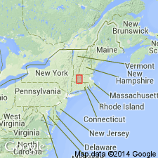
- Areal extent
- Age modified
- Dominant lithology:
-
- Phyllite
- Granulite
- AAPG geologic province:
-
- New England province
Summary:
Putney Volcanics is used in accordance with Hepburn (1972, unpublished Ph.D. thesis, and NEIGC field trip guidebook). Rocks were previously included in Standing Pond Volcanics by Billings, 1955, NH State map) and in Standing Pond volcanic member of Waits River Formation by Doll and others (1961, VT State map). Because of differing lithology (less mafic) and inability to trace these rocks into type Standing Pond, these rocks were given a new formation name by Hepburn (1972). Consists of light-greenish-gray, fine-grained, poorly foliated phyllite and granulite, both containing interbedded gray phyllite. Includes lenses of quartz-pebble conglomerate containing quartzite and slate fragments in slate matrix in a few outcrops on east side of formation. Forms a belt in Connecticut Valley synclinorium, from approx 8 km north of Springfield, southeastern VT to 1.5 km northwest of Bernardston, north-central MA. Thickness ranges from a few to 130 m along strike. Age is probably Devonian, constrained by Early Devonian age of Littleton Formation and probable Devonian age of Gile Mountain Formation.
Source: GNU records (USGS DDS-6; Reston GNULEX).

- Usage in publication:
-
- Putney Volcanics*
- Modifications:
-
- Overview
- AAPG geologic province:
-
- New England province
Summary:
Used as Putney Volcanics of Early Devonian age.
Source: GNU records (USGS DDS-6; Reston GNULEX).
- Usage in publication:
-
- Putney Volcanics*
- Modifications:
-
- Age modified
- AAPG geologic province:
-
- New England province
Summary:
Age of Putney Volcanics changed from Devonian to Early Devonian based on work by Robinson and others (1984, GSA Abstract). Correlations preferred by some workers imply a Silurian age.
Source: GNU records (USGS DDS-6; Reston GNULEX).
- Usage in publication:
-
- Putney Volcanics*
- Modifications:
-
- Overview
- AAPG geologic province:
-
- New England province
Summary:
Putney Volcanics described as light-greenish-gray to white, very fine grained, poorly foliated phyllite to granulite in a discontinuous belt as much as 130 m wide. Exposed in MA in small area at north end of Deerfield Mesozoic basin. First mapped by Balk (1956) as occurring within his Leyden Argillite [approx the same as present-day Littleton Formation]. Doll and others (1961), in adjacent southern VT, included these rocks in Standing Pond Volcanic Member of Waits River Formation on their Centennial Geologic Map of Vermont, despite that they showed the rocks, as do Zen and others (1983) on the MA State geologic map, at the Gile Mountain-Littleton formational contact, totally isolated from Waits River Formation. Trask (1964) applied the name Standing Pond Volcanics to these rocks in northern MA and southern VT, treating them as a discrete formation. Hepburn (1972), in remapping southeasternmost VT, called the rocks Putney Volcanics in order to distinguish them from other parts of the Standing Pond. Trask (1980) then extended the name Putney into northern MA, and pointed out that Putney Volcanics is not physically traceable into Standing Pond Volcanics. Furthermore, amphibolites in Gile Mountain and Waits River Formations probably correlate with the Standing Pond as they are more mafic in composition. Standing Pond and correlatives in VT and MA are everywhere at or near Waits River-Gile Mountain contact; Putney Volcanics is at or near Gile Mountain-Littleton contact. Further mapping needed to establish continuity between Putney and Standing Pond. Because it is sandwiched in between two Lower Devonian formations, Putney is assigned an Early Devonian age. [Papers presented as chapters in U.S. Geological Survey Professional Paper 1366 are intended as explanations and (or) revisions to MA State bedrock geologic map of Zen and others (1983) at scale of 1:250,000.]
Source: GNU records (USGS DDS-6; Reston GNULEX).
For more information, please contact Nancy Stamm, Geologic Names Committee Secretary.
Asterisk (*) indicates published by U.S. Geological Survey authors.
"No current usage" (†) implies that a name has been abandoned or has fallen into disuse. Former usage and, if known, replacement name given in parentheses ( ).
Slash (/) indicates name conflicts with nomenclatural guidelines (CSN, 1933; ACSN, 1961, 1970; NACSN, 1983, 2005, 2021). May be explained within brackets ([ ]).