The National Geologic Map Database is migrating to a new infrastructure. We apologize for any service disruptions during this process.
|
|---|


- Usage in publication:
-
- Purcell glaciation
- Modifications:
-
- Named
- Dominant lithology:
-
- Till
- AAPG geologic province:
-
- Black Mesa basin
Summary:
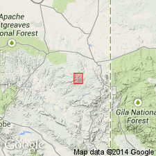
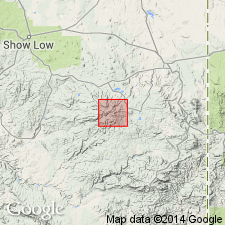
Is the oldest glaciation in report area. Named for Purcell Cienega in upper reaches of West Fork of Black River, Apache Co, AZ in the Black Mesa basin. No type locality designated. Map shows areal extent of glaciations in the White Mountains of Apache Co. Rocks of this glaciation were previously assigned to the Ord Creek glaciation, a term no longer used. Lacks morainal topography due to subsequent stream erosion. Large concentration of erratics 3 or 4 m in diameter and some till present on floor of Purcell Cienega. The boulders have deeply pitted surfaces. Soils on the moraines are mature. This glaciation was probably the most extensive of the glaciations in the White Mountains. The glacier probably was about 4 km long and had a terminal elevation of about 9,500 ft. Deposits of Purcell age are rare to nonexistent on West Fork of Colorado River and East Fork of White River, but the valley shape and presence of occasional erratics suggests glaciers did occupy these valleys in Purcell time. Moraines assigned to this glaciation identified on Ord and Paradise Creeks at elevations of 9,300 and 9,800 ft respectively. Considered to be of Pleistocene, pre-Wisconsinan age. Is the oldest of 4 glaciations named in report. Is older than the Smith Cienega glaciation (named). Correlation chart.
Source: GNU records (USGS DDS-6; Denver GNULEX).
- Usage in publication:
-
- Purcell glaciation
- Modifications:
-
- Overview
- AAPG geologic province:
-
- Black Mesa basin
Summary:
Only remnants of till and moraines of Purcell time exist. Represented by the oldest glacial deposits in the Mount Baldy area, White Mountains of Apache Co, AZ, Black Mesa basin. Occurs as isolated remnants of till usually lacking constructional form. Greatest accumulation of boulders is at lower end of Purcell Cienega with lesser concentrations in small tributaries crossing the Cienega. Weathering-rinds on the erratics is about 1.2 cm thick; moderate feldspar weathering occurs to depth of 5 cm. Moderate soil developed on lateral and terminal moraines, soil description included. Most boulders derived from Ord Creek Valley and are varieties of latite and quartz latite. Till occurs on Paradise Creek. Also includes glaciofluvial deposits (stratified sand and gravel) and lacustrine deposits (gray bouldery clay). Map shows extent of glaciers in Purcell time. Table compares Purcell deposits with those of younger glaciations in Mount Baldy area. Considered to be pre-Wisconsinan due to advanced weathering. Might be Illinoiian age.
Source: GNU records (USGS DDS-6; Denver GNULEX).
For more information, please contact Nancy Stamm, Geologic Names Committee Secretary.
Asterisk (*) indicates published by U.S. Geological Survey authors.
"No current usage" (†) implies that a name has been abandoned or has fallen into disuse. Former usage and, if known, replacement name given in parentheses ( ).
Slash (/) indicates name conflicts with nomenclatural guidelines (CSN, 1933; ACSN, 1961, 1970; NACSN, 1983, 2005, 2021). May be explained within brackets ([ ]).