

- Usage in publication:
-
- Pyror member
- Modifications:
-
- Original reference
- Dominant lithology:
-
- Limestone
- AAPG geologic province:
-
- Gulf Coast basin
Summary:
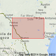
Pg. 20-21; 1962, IN Contributions to the geology of south Texas: San Antonio, South Texas Geol. Soc., p. 86, 92. Pryor member of Georgetown formation of Atascosa group (new). Name proposed for thick limestone unit overlying McKnight formation (new) and underlying typical Georgetown of San Marcos basin, southern Texas (subsurface). Age is Early Cretaceous.
Type section (subsurface): depth-interval 2,720 to 3,022 ft (well depth), T.P. Cannon No. 1 A. Finley well, northwestern Zavala Co., southern TX.
Source: US geologic names lexicon (USGS Bull. 1350, p. 601-602).
For more information, please contact Nancy Stamm, Geologic Names Committee Secretary.
Asterisk (*) indicates published by U.S. Geological Survey authors.
"No current usage" (†) implies that a name has been abandoned or has fallen into disuse. Former usage and, if known, replacement name given in parentheses ( ).
Slash (/) indicates name conflicts with nomenclatural guidelines (CSN, 1933; ACSN, 1961, 1970; NACSN, 1983, 2005, 2021). May be explained within brackets ([ ]).