

- Usage in publication:
-
- Prince Creek formation*
- Modifications:
-
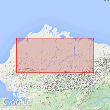
- Named
- Dominant lithology:
-
- Sandstone
- Conglomerate
- Shale
- Coal
- Bentonite
- Tuff
- AAPG geologic province:
-
- Alaska Northern region
Summary:
Named as formation in Colville group. Type locality designated as near Prince Creek tributary of Colville River, northern AK. Includes nonmarine beds above Niakogon tongue (new) of Chandler formation (new) of Nanushuk group. Lower part, 1200 ft thick, is Tuluvak tongue (new); upper part, 2340 ft thick, is Kogosukruk tongue (new). Consists of sandstone, conglomerate, shale, coal, bentonite, and tuff. Intertongues with marine Schrader Bluff formation of Colville group. Unconformably overlies Nanushuk group. Structurally conformable with overlying Sagavanirktok formation (new) and unconformably underlies Gubik formation. Contains fresh- to brackish-water mollusks. Age given as Early Cretaceous.
Source: GNU records (USGS DDS-6; Menlo GNULEX).
- Usage in publication:
-
- Prince Creek Formation*
- Modifications:
-
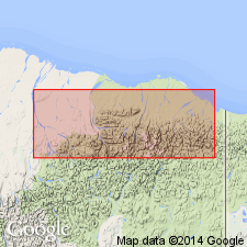
- Areal extent
- AAPG geologic province:
-
- Alaska Northern region
Summary:
Geographically extended to northeast AK. Prince Creek and Schrader Bluff Formations form northeast-trending belt 8 to 24 km (5 to 15 mi) wide between Sagavanirktok and Aichilik Rivers. Some strata formerly included as upper member of Ignek Formation by Keller and others (1961). Age is Late Cretaceous based on stratigraphic relations.
Source: GNU records (USGS DDS-6; Menlo GNULEX).
- Usage in publication:
-
- Prince Creek Formation*
- Modifications:
-
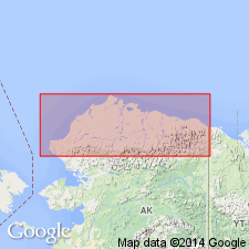
- Revised
- Age modified
- AAPG geologic province:
-
- Alaska Northern region
Summary:
Pg. 5 (fig. 4), 6-8 (table 1), 30+. Prince Creek Formation. Revised. Removed from †Colville Group (abandoned). Tuluvak Tongue, lower tongue of Prince Creek, is removed and raised to formation rank. Includes (1) beds originally assigned to †Kogosukruk Tongue (abandoned); and (2) brown-weathering, coal-bearing rocks previously assigned to lower part of Sagwon Member (restricted) of Sagavanirktok Formation. As revised, is dominantly nonmarine sandstone, conglomerate, and interbedded coal-bearing mudstone. Total thickness unknown; lower part about 1,200 feet. Overlies and interfingers with Upper Cretaceous Sentinel Hill Member of Schrader Bluff Formation. Unconformably underlies Paleocene Sagwon Member (restricted) of Sagavanirktok Formation. Is temporal equivalent of West Sak and lower Ugnu sands (Werner, 1987, SEPM-Pacific Sec., Book 50, v. 1) in subsurface of Kuparuk River oil field area. Fossils. Age is Late Cretaceous to early Tertiary (Campanian to early Paleocene).
Typical exposures (lower part): upper part of Shivugak Bluff along north and west side of Colville River, downstream from Umiat, in secs. 17, 18, and 19, T. 1 N., R. 2 E. [Umiat B-3 quadrangle, scale 1:63.360], northern AK; and bluffs along west side of Colville River, downstream from mouth of Anaktuvuk River, in secs. 6 and 7, T. 2 N., R. 3 E. [Umiat C-3 quadrangle, scale 1:63.360], northern AK.
Source: Publication.
For more information, please contact Nancy Stamm, Geologic Names Committee Secretary.
Asterisk (*) indicates published by U.S. Geological Survey authors.
"No current usage" (†) implies that a name has been abandoned or has fallen into disuse. Former usage and, if known, replacement name given in parentheses ( ).
Slash (/) indicates name conflicts with nomenclatural guidelines (CSN, 1933; ACSN, 1961, 1970; NACSN, 1983, 2005, 2021). May be explained within brackets ([ ]).