The National Geologic Map Database is migrating to a new infrastructure. We apologize for any service disruptions during this process.
|
|---|


- Usage in publication:
-
- Prairie Farm Member
- Modifications:
-
- Principal reference
- Dominant lithology:
-
- Till
- Sand
- Silt
- Clay
- AAPG geologic province:
-
- Wisconsin arch
Summary:
Pg. vi (chart), 14-18. Prairie Farm Member of River Falls Formation. Formal definition. (Follows informal usage of M.D. Johnson, 1986, Wisconsin Geol. Nat. Hist. Survey Inf. Circ., no. 55, 42 p., and M.D. Johnson, 1984, Univ. Wisconsin PhD dissert.)
Till. Yellowish red to dark-brown, unbedded, slightly gravelly to gravelly sandy loam, and in part, loamy sand. Thickness in outcrop <2 m; well logs indicate thickness up to 10 m. Where exposed, overlies Cambrian sandstone with sharp contact and underlies loess with sharp or gradational contact. Extends northward to margins of Pokegama Creek Member (new) and Poskin Member (new), both of Copper Falls Formation. Prairie Farm included with other till units of River Falls Formation because of similar grain size, color, magnetic suseptibility, and clay-mineral content. Interpreted as having been deposited by south- and southwest-flowing ice during Dallas advance of Chippewa Lobe. Age is unknown, but probably deposited before Wisconsin Glaciation, based on weathering characteristics and stratigraphic relations. Baker and others, 1983 (GSA Bull., v. 94, p. 1442-1449) concluded deposition of River Falls Formation was either during Illinoian Glaciation or early Wisconsin Glaciation. Age is considered Pleistocene (pre-Wisconsinan or early Wisconsinan).
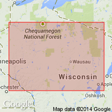
Type section: roadcut on south side of an east-west road, in NE/4 NW/4 SE/4 sec. 13, T. 32 N., R. 13 W., [approx. Lat. 45 deg. 15 min. 32 sec. N., Long. 91 deg. 55 min. 05 sec. W.], Dority Creek 7.5-min quadrangle, Barron Co., western WI.
Named from community of Prairie Farm, Barron Co., western WI [a few mi southwest of type section]; name credited to Mark D. Johnson.
Reference sections:
(1) till; in roadcut on north side of east-west road, in SW/4 SW/4 SW/4 sec. 19, T. 33 N., R. 12 W., [approx. Lat. 45 deg. 19 min. 23 sec. N., Long. 91 deg. 54 min. 36 sec. W.], Dority Creek 7.5-min quadrangle, Barron Co., western WI; and
(2) sand; in pit, in SW/4 SW/4 SW/4 sec. 3, T. 31 N., R. 9 W., [approx. Lat. 45 deg. 12 min. 00 sec. N., Long. 91 deg. 30 min. 41 sec. W.], New Auburn 7.5-min quadrangle, Chippewa Co., western WI.
[Additional locality information from USGS historical topographic map collection TopoView, accessed on June 9, 2018.]
Source: Publication.
For more information, please contact Nancy Stamm, Geologic Names Committee Secretary.
Asterisk (*) indicates published by U.S. Geological Survey authors.
"No current usage" (†) implies that a name has been abandoned or has fallen into disuse. Former usage and, if known, replacement name given in parentheses ( ).
Slash (/) indicates name conflicts with nomenclatural guidelines (CSN, 1933; ACSN, 1961, 1970; NACSN, 1983, 2005, 2021). May be explained within brackets ([ ]).