

- Usage in publication:
-
- Port Jervis limestone and chert
- Modifications:
-
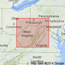
- Areal extent
- AAPG geologic province:
-
- Appalachian basin
Summary:
Unit referred to as Port Jervis limestone and chert in Helderberg group. Geographically extended into WV. At type locality in southeastern NY, limestone is about 30 ft thick and consists of blue-gray partly siliceous or finely arenaceous limestone with specimens of DALMANITES, RENSSELARAERIA, and HOMALONOTUS. In central eastern PA, formation disappears in an erosional unconformity between Oriskany sandstone and early members of Helderberg group. It is believed to reappear in Franklin Co., southern PA, and continue southward across MD, into WV. In this belt, it occupies more of the Licking Creek limestone of Swartz (1938). Formation thins and is absent in Massanutten syncline of northern VA. Overlies Port Ewen limestone; underlies Ridgeley sandstone. Equivalent to part of Shriver chert or "Becraft limestone" of previous reports. Thickness as much as 90 ft. Age is Early Devonian.
Source: GNU records (USGS DDS-6; Reston GNULEX).
For more information, please contact Nancy Stamm, Geologic Names Committee Secretary.
Asterisk (*) indicates published by U.S. Geological Survey authors.
"No current usage" (†) implies that a name has been abandoned or has fallen into disuse. Former usage and, if known, replacement name given in parentheses ( ).
Slash (/) indicates name conflicts with nomenclatural guidelines (CSN, 1933; ACSN, 1961, 1970; NACSN, 1983, 2005, 2021). May be explained within brackets ([ ]).