The National Geologic Map Database is migrating to a new infrastructure. We apologize for any service disruptions during this process.
|
|---|


- Usage in publication:
-
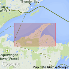
- Porcupine Volcanics*
- Modifications:
-
- Named
- Dominant lithology:
-
- Volcanics
- Basalt
- Andesite
- Lava
- Siltstone
- Conglomerate
- AAPG geologic province:
-
- Wisconsin arch
Summary:
Named as formation in Bergland Group (new). Named for Porcupine Mountains, Ontonagon Co., northwestern MI (Upper Peninsula). Includes rocks formerly called the "unnamed formation" or Oak Bluff Formation by many workers. Oak Bluff is not an appropriate name because dominant rock type, rhyolite, doesn't occur at Oak Bluff. Exposed for strike length of nearly 100 km along main trend of Keweenawan monocline from near town of Greenland in Ontonagon Co. to near Wisconsin border in western Gogebic Co. Also exposed in structural repetition of strata in highlands of Porcupine Mountains. Consists of sequence of subaerially deposited basalt, andesite, felsite [rhyolite], quartz-porphyry lava flows, and minor interbedded sandstone, siltstone, and conglomerate. Distinguished from underlying Portage Lake Volcanics by having about 25 percent felsic rocks and predominance of andesite. Andesite flows are dark gray to grayish red or grayish purple, are fine grained, and average about 8 m thickness. Rhyolite occurs as subaerial domes or flows, mostly near top of formation. Total exposed thickness ranges from 750 to 2500 m; base not exposed. Conformably overlies Portage Lake Volcanics; probably interbedded with overlying Copper Harbor Conglomerate, but relationship needs more study. Report includes geologic map and correlation chart. Age is Middle Proterozoic.
Source: GNU records (USGS DDS-6; Reston GNULEX).
For more information, please contact Nancy Stamm, Geologic Names Committee Secretary.
Asterisk (*) indicates published by U.S. Geological Survey authors.
"No current usage" (†) implies that a name has been abandoned or has fallen into disuse. Former usage and, if known, replacement name given in parentheses ( ).
Slash (/) indicates name conflicts with nomenclatural guidelines (CSN, 1933; ACSN, 1961, 1970; NACSN, 1983, 2005, 2021). May be explained within brackets ([ ]).