

- Usage in publication:
-
- Popotosa formation
- Modifications:
-
- Original reference
- Dominant lithology:
-
- Sandstone
- Conglomerate
- Tuff
- AAPG geologic province:
-
- Orogrande basin
Summary:
Pg. 77-84. Popotosa formation. Consists of debris eroded from volcanic rocks, plus small amount of tuff which was contributed by relatively small contemporaneous eruptions. Highly faulted. Estimated minimum thiclmess 3,000 feet; possible maximum 5,000 feet. Unconformably overlies volcanic rocks of Miocene(?) age to east of Silver Creek; underlies Santa Fe formation. Age is late Miocene.
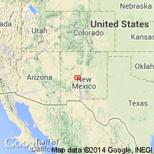
Well exposed in Silver Creek valley, in T. 1 N., R. 2 W., San Acacia area, Socorro Co., central NM. Named from Arroyo Popotosa [Canada Popotosa, west of Sierra Ladrones, Sevilleta National Wildlife Refuge, San Acacia 7.5-min quadrangle, Socorro Co., central NM].
Source: US geologic names lexicon (USGS Bull. 1200, p. 3098).
- Usage in publication:
-
- Popotosa Formation*
- Modifications:
-
- Revised
- Reference
- AAPG geologic province:
-
- Orogrande basin
Summary:
Revised in Orogrande basin, NM in that it is assigned as lower formation of Miocene age of Santa Fe Group. Consists of several intertonguing facies: 1) fanglomerate, a gray to brown, moderately to strongly indurated subangular with interbedded sandy units, gravel-size clasts are predominately from Precambrian and upper Paleozoic rocks of Ladron Mountains; 2) volcaniclastic fanglomerate, gray to red-brown, moderately to strongly indurated subangular fanglomerate and medium- to thickly bedded sandstone; 3) playa beds, brown or gray-green, poorly sorted silty clay to sand with sparse pebbly lenses, abundant gypsum, and numerous ash beds; and 4) transitional beds, brown, well-cemented, moderately well sorted, fine- to medium-grained sandstone. Dated as early to late? Miocene on basis of K-Ar dates (9.1 +/-0.5 m.y.) on interbedded volcanic units. Reference section designated from north edge Cerritos de las Minas west to Tortula Spring, a section 1,860 m thick. Equivalent to: Haymer Ranch and Rincon Valley Formations of Las Cruces area, to Zia Sand and Cochiti Formations near Albuquerque, and Tesugue Formation near Santa Fe. Is overlain by the Sierra Ladrones Formation of the Santa Fe.
Source: GNU records (USGS DDS-6; Denver GNULEX).
- Usage in publication:
-
- Popotosa Formation*
- Modifications:
-
- Age modified
- AAPG geologic province:
-
- Orogrande basin
Summary:
Age of late Oligocene to late Miocene (formerly only Miocene) accepted on basis of dates given in Machette (1972), and on relationship found in a section in the Socorro basin of the Orogrande basin, where older Popotosa is found beneath the 26 m.y. old andesite flow. Contains as many as 12 tuffs. Is more than 1,500 m thick.
Source: GNU records (USGS DDS-6; Denver GNULEX).
- Usage in publication:
-
- Popotosa Formation
- Modifications:
-
- Revised
- AAPG geologic province:
-
- Orogrande basin
Summary:
Is lower formation of Santa Fe Group in Socorro-Magdalena area, Orogrande basin, NM. Consists of 3,000+ ft of fanglomerate, mudflow, mudstone, and sandstone deposits interbedded with basalt. Two basalts informally named. Basalt of Broken Tank is a 0-150 ft thick grayish-black, microvesicular slightly porphyritic basaltic lava flow that occurs in west-central Chupadera Mountains. Its source is unknown. It has not been dated. Basalt of Bear Canyon is a 0-50 ft thick dense, black, fine-grained basalt with ophitic texture that occurs in the Socorro area and is thin, local discontinuous, has not been dated, its source is unknown, and is interbedded with playa-claystone facies of Popotosa. Includes the informal unit of Arroyo Montosa, fanglomerate of Dry Lake Canyon, basalts of Kelly Ranch and Madera Canyon, basaltic andesite of Council Rock, and rhyolite of Water Canyon. Age of Popotosa ranges from 27 m.y. to 7 m.y. based on ages of interbedded La Jara Peak Andesitic Basalt (27.0 and 27.3 m.y.) and unnamed rhyolite domes and flows (7 m.y.). Assigned to Miocene. Occurs usually above South Canyon Tuff (new), but "Popotosa-like" sediments occur beneath South Canyon. Interbedded with La Jara Peak Basaltic Andesite, Socorro Peak (new) and Magdalena Peak (new) Andesites. Underlies Sierra Ladrones Formation of Santa Fe.
Source: GNU records (USGS DDS-6; Denver GNULEX).
- Usage in publication:
-
- Popotosa Formation*
- Modifications:
-
- Principal reference
- Dominant lithology:
-
- Sandstone
- Siltstone
- Conglomerate
- Tuff
- AAPG geologic province:
-
- Orogrande basin
Summary:
Popotosa Formation of Santa Fe Group. Conglomerate, granulestone, sandstone, siltstone, mudstone, and tuffs. Measured thickness 1,316 m at principal reference section and 1,447 m at reference section. Unconformably underlies Sierra Ladrones Formation or Quaternary sediments; unconformably overlies and interlayered with La Jara Peak Basaltic Andesite. Age is possibly late Oligocene(?) to Miocene, based on radiometric ages.
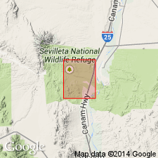
Principal reference section: Silver Creek, Sevilleta National Wildlife Refuge, [approx.] Lat. 34 deg. 18 min. 00 sec. N., Long. 107 deg. 02 min. 30 sec. W., Riley 15-min quadrangle, Socorro Co., central NM.
Reference section: Canoncito de las Cabras, in NW/4 SE/4 sec. 13, T. 1 S., R. 1 W., and secs. 17 and 18, T. 1 S., R. 2 W., Magdalena 15-min and Lemitar 7.5-min quadrangles, Socorro Co., central NM.
Source: Publication.
For more information, please contact Nancy Stamm, Geologic Names Committee Secretary.
Asterisk (*) indicates published by U.S. Geological Survey authors.
"No current usage" (†) implies that a name has been abandoned or has fallen into disuse. Former usage and, if known, replacement name given in parentheses ( ).
Slash (/) indicates name conflicts with nomenclatural guidelines (CSN, 1933; ACSN, 1961, 1970; NACSN, 1983, 2005, 2021). May be explained within brackets ([ ]).