

- Usage in publication:
-
- Polk Creek shale*
- Modifications:
-
- Original reference
- Dominant lithology:
-
- Shale
- AAPG geologic province:
-
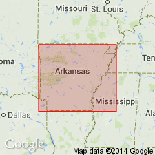
- Ouachita folded belt
Summary:
Pg. 30, 36; GSA Bull., v. 19, p. 557, 1909 [abs.]. Polk Creek shale. Shale resembling Ouachita shale in color, hardness, and texture, in presence of large number of quartz veins, and in locally having well-developed slaty cleavage. Differs from Ouachita shale in containing no sandy or calcareous layers and in being only about 100 feet thick; in places appears to be absent. Overlies Bigfork chert and underlies [unconformably?] Blaylock sandstone. [Recognized in southwestern Arkansas and southeastern Oklahoma. Age is Late Ordovician (Richmond).]
[Named from Polk Creek, Montgomery Co., southwestern AR.]
Source: US geologic names lexicon (USGS Bull. 896, p. 1695).
- Usage in publication:
-
- Polk Creek shale*
- Modifications:
-
- Areal extent
- AAPG geologic province:
-
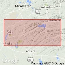
- Ouachita folded belt
Summary:
Pg. 781 (fig. 2), 787. Polk Creek shale. Described in Ouachita Mountains of southeastern Oklahoma where it is well developed at Black Knob Ridge and in the Potato Hills. In most exposures, shale is somewhat altered, hard, siliceous, and darker than the normal Sylvan; lower part is dark gray to black, dolomitic, and resembles "Normal Sylvan" of the Arbuckles; it includes the black bituminous type at its base, everywhere along south front of mountains east of Ardmore on Highway 77 and at Apache; the remainer, approximately 60 feet, consists of rather soft dark-greenish to greenish-gray platy shale, which is indistinguishable from the Sylvan of the Arbuckles. Unconformably overlies Big Fork chert; unconformably underlies Missouri Mountain shale. Age is Silurian.
Source: US geologic names lexicon (USGS Bull. 1200, p. 3086).

- Usage in publication:
-
- Polk Creek Shale*
- Polk Creek Formation*
- Modifications:
-
- Overview
- AAPG geologic province:
-
- Ouachita folded belt
Summary:
Pg. 20. Polk Creek Shale; Polk Creek Formation. Black, sooty, fissile shale with minor black chert and traces of gray quartzite and limestone. Thickness from about 50 to 225 feet. Rests conformably on Bigfork Chert. Graptolites are common in most of the shales in the formation. Age is Late Ordovician.
Named from Polk Creek, Caddo Gap quadrangle, Montgomery Co., AR (Purdue, 1909a, 1909b). Recognized in Ouachita Mountains, west-central AR, and in southeastern OK.
Source: Publication.
For more information, please contact Nancy Stamm, Geologic Names Committee Secretary.
Asterisk (*) indicates published by U.S. Geological Survey authors.
"No current usage" (†) implies that a name has been abandoned or has fallen into disuse. Former usage and, if known, replacement name given in parentheses ( ).
Slash (/) indicates name conflicts with nomenclatural guidelines (CSN, 1933; ACSN, 1961, 1970; NACSN, 1983, 2005, 2021). May be explained within brackets ([ ]).