

- Usage in publication:
-
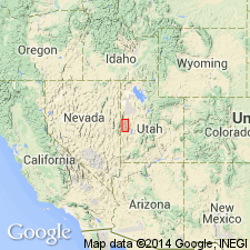
- Plympton formation*
- Modifications:
-
- Named
- Dominant lithology:
-
- Chert
- Dolomite
- AAPG geologic province:
-
- Great Basin province
Summary:
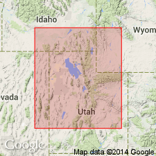
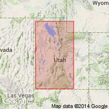
Name applied to rocks formerly assigned to Phosphoria formation in Confusion Range that overlie Kaibab limestone and underlie Gerster limestone. Kaibab, Plympton, Gerster assigned to Park City group; is very different than type Phosphoria. Named Plympton for exposures on Millard and Plympton ridges, Juab and Millard Cos., UT, Great Basin province. Defined on basis of 2 partially measured sections -1.) 1.4 mi N60 degrees E of end Indian Pass, and 2.) 9 mi S2 degrees W of Granite Mountain (Juab Co.). Despite wide distribution, no single complete, well exposed section known. Has a composite thickness of 690 ft. Contact with Kaibab is sharp, a change from resistant dolomite to slope-forming brown chert of Plympton. Has 5 zones (ascending). First is 20-25 ft of bedded gray to brown chert and minor gray dolomite. Second is 110-115 ft thick of very finely crystalline dolomite with spheroidal, rusty-brown to brown-black weathering chert nodules; chert nodules are flattened in lower part. Third is 115 ft thick bedded gray chert (predominant), collophane-bearing dolomite, and sparse stringers of pelletal phosphorite and silty dolomite. Fourth is about 125 ft thick, predominantly finely crystalline dolomite with abundant chert nodules, disseminated silica, and chert along bedded surfaces. Fifth is 310 ft thick of (decreasing abundance) dolomite, chert, carbonate breccia, sandstone, siltstone, gypsum. Cross sections. No fossils found. Correlated with phosphatic mudstone and cherty shale of Phosphoria, and extension of Franson member and Meade Peak tongue, and upper few hundred feet of Oquirrh formation.
Source: GNU records (USGS DDS-6; Denver GNULEX).
- Usage in publication:
-
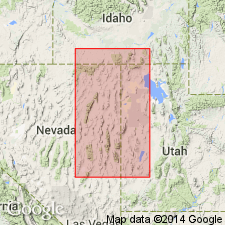
- Plympton Formation
- Modifications:
-
- Revised
- AAPG geologic province:
-
- Great Basin province
Summary:
Park City Group divided into (ascending): Kaibab Limestone, Plympton Formation, Indian Canyon Formation (newly named), and Gerster Formation. Park City overlies the Loray Formation and underlies the Thaynes Limestone. Areal extent map show general distribution of all 4 formations in NV and UT, Great Basin province Kaibab has the greatest areal extent in NV and UT. The upper 3 formations are mostly in Elko and White Pine Cos., NV and they extend a short distance into Box Elder, Tooele, and Juab Cos., UT. Columnar stratigraphic sections show lithology of each unit drawn from measured sections in the Leppy Hills area, UT-NV border, at Gold Hill district, UT, and in the Pequop Mountains of NV.
Source: GNU records (USGS DDS-6; Denver GNULEX).
- Usage in publication:
-
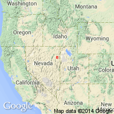
- Plympton Formation*
- Modifications:
-
- Areal extent
- Overview
- AAPG geologic province:
-
- Great Basin province
Summary:
Mapped in southern Pequop Mountains, Elko Co., NV, Great Basin province as the middle formation of the Park City Group. Overlies Kaibab Limestone, basal formation of the group, and underlies Gerster Limestone, upper formation of the group. 5 zones or parts [of? Hose and Repenning in Confusion Range] recognized. About 1,000 to 1,200 ft thick. Much of formation is covered; parts form ridges. Large collection of scaphopods, gastropods, and pelecypods collected in zone, or part, 5, the top zone. These fossils assembled under strong water movement. Specimens were probably moved a few ft to a few tens of ft vertically; wear on fossils indicates a high energy environment; water shallow; laid down in a storm bed. Faunule is late Leonardian -early Wordian age. Scaphopod fauna described.
Source: GNU records (USGS DDS-6; Denver GNULEX).
- Usage in publication:
-
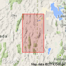
- Plympton Formation*
- Modifications:
-
- Overview
- AAPG geologic province:
-
- Great Basin province
Summary:
Rocks of Unit 5 of Plympton Formation of Park City Group are variable; they include dolomite, bedded chert, gypsum, possibly collapse breccias, and dolomite siltstone. The name Indian Canyon Formation (of Park City Group) was applied in the southern Pequop Mountains, but that name has not been used. Report area extends from Medicine Lodge to southern Pequop Mountains, NV to Gold Hill and Confusion Range, UT, Great Basin province where Park City Group of late Leonardian to early Guadalupian, Early Permian age can be divided into (ascending): Kaibab Limestone, Plympton Formation, and Gerster Limestone Cross sections. Isopach map of Gerster Limestone. Faunal lists.
Source: GNU records (USGS DDS-6; Denver GNULEX).
- Usage in publication:
-
- Plympton Formation*
- Modifications:
-
- Overview
- AAPG geologic province:
-
- Great Basin province
Summary:
Assigned as middle formation of Park City Group in Cedar Mountains of UT (Tooele Co.) in the Great Basin province. Is separated from Kaibab Limestone of Park City Group by the Meade Peak Tongue of the Phosphoria Formation. Underlies Gerster Limestone of Park City Group. Nomenclature diagram. Cross sections. Plympton tongues into Murdock Mountain Formation of Park City Group in the Terrace Mountains of Box Elder Co., UT to north and in the Leach Mountains of Elko Co., NV.
Source: GNU records (USGS DDS-6; Denver GNULEX).
- Usage in publication:
-
- Plympton Formation
- Modifications:
-
- Revised
- AAPG geologic province:
-
- Great Basin province
Summary:
Assigned as upper formation of Kaibab Group in Beaver Dam Mountains of Washington Co., UT in the Great Basin province. Dolomite unconformably above the White Rim Sandstone in UT in the Capitol Reef area and unconformably above the Cedar Mesa Sandstone in the San Rafael area formerly assigned to the Kaibab Limestone is removed from the Kaibab and reassigned to the newly named Black Box Dolomite. Term Kaibab is restricted geographically to two areas of southwest UT discussed in this report--Marysvale and Beaver Dam. Kaibab considered --at Marysvale, to be of group rank in this report and is divided into: 1) Toroweap Formation (basal unit) and Fossil Mountain Limestone (top); and 2) Beaver Dam Mountains --Seligman (base) and Brady Canyon Limestones, Woods Ranch Formation, Kaibab Limestone, ["when a unit is divided into two or more of the same rank as the original, the original name should not be used for any of the divisions." NASC, 1983, art. 19g.], and Plympton Formation (top) in the Beaver Dam Mountains. Black Box shown as equivalent to Kaibab of the Beaver Dam Mountains. Cross section. Permian age. [Intent or reason to modify rank of Kaibab not stated.]
Source: GNU records (USGS DDS-6; Denver GNULEX).
For more information, please contact Nancy Stamm, Geologic Names Committee Secretary.
Asterisk (*) indicates published by U.S. Geological Survey authors.
"No current usage" (†) implies that a name has been abandoned or has fallen into disuse. Former usage and, if known, replacement name given in parentheses ( ).
Slash (/) indicates name conflicts with nomenclatural guidelines (CSN, 1933; ACSN, 1961, 1970; NACSN, 1983, 2005, 2021). May be explained within brackets ([ ]).