The National Geologic Map Database is migrating to a new infrastructure. We apologize for any service disruptions during this process.
|
|---|


- Usage in publication:
-
- Pittsburg formation
- Modifications:
-
- First used
- Dominant lithology:
-
- Conglomerate
- Sandstone
- AAPG geologic province:
-
- Idaho Mountains province
Summary:
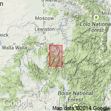
First published use as a name for some sedimentary rocks unconformably above the Permian Seven Devils volcanics. Is older than the Upper Triassic Lucile series (named). No type locality designated. Known only on the ID side of the Snake River over an area of about 1.5 sq mi in Idaho Co, ID in the Idaho Mountains province, and on the OR side of the Snake River over an undetermined area. Geologic map. Consists mostly of gray-green conglomerate and sandstone. The conglomerate is made up of subangular to rounded pebbles and boulders 1 to 4 inches in diameter in a coarse, gray-green sandy matrix. Consists of debris eroded from the Permian volcanics. Estimated to be 200-300 ft thick. Intruded by rocks of Idaho batholith. Tentatively assigned to the Carboniferous.
Source: GNU records (USGS DDS-6; Denver GNULEX).
- Usage in publication:
-
- Pittsburg Formation*
- Modifications:
-
- Not used
Summary:
Name replaced by Kurry Creek Member (named), a clastic sequence within the upper part of the Doyle Creek Formation (named), upper formation of Seven Devils Group (formerly Seven Devils Volcanics). Pittsburg thought to be Carboniferous, but Late Triassic (late Karnian to middle Norian) ammonites have been identified. Kurry Creek is a local unit that crops out only in the Pittsburg Landing area, Idaho Co, ID, Idaho Mountains province.
Source: GNU records (USGS DDS-6; Denver GNULEX).
For more information, please contact Nancy Stamm, Geologic Names Committee Secretary.
Asterisk (*) indicates published by U.S. Geological Survey authors.
"No current usage" (†) implies that a name has been abandoned or has fallen into disuse. Former usage and, if known, replacement name given in parentheses ( ).
Slash (/) indicates name conflicts with nomenclatural guidelines (CSN, 1933; ACSN, 1961, 1970; NACSN, 1983, 2005, 2021). May be explained within brackets ([ ]).