The National Geologic Map Database is migrating to a new infrastructure. We apologize for any service disruptions during this process.
|
|---|


- Usage in publication:
-
- Pitahaya Formation*
- Modifications:
-
- Named
- Dominant lithology:
-
- Lava
- Breccia
- Tuff
- AAPG geologic province:
-
- Caribbean region
Summary:
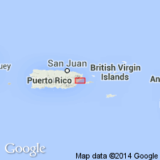
Named Pitahaya Formation of Pitahaya, PR. Unit consists of 2000 meters of lava, autoclastic breccia, tuff and tuff breccia, and volcanic sandstone; dark-greenish-gray to olive or brownish black lava, medium- to brownish-gray tuff and sandstone. The Pitahaya is in fault contact with the Rio Abajo Formation, but may unconformably overlie it west of the study area; it is in intrusive contact with Tertiary(?) plutonic rocks of San Lorenzo batholith; unconformably underlies Quaternary deposits. It is considered to be of Early Cretaceous age.
Source: GNU records (USGS DDS-6; Reston GNULEX).

- Usage in publication:
-
- Pitahaya Formation*
- Modifications:
-
- Overview
- AAPG geologic province:
-
- Caribbean region
Summary:
The Pitahaya Formation occurs in central Puerto Rico and consists of pillowed lava, hyaloclastite breccia, flow breccia, tuff, and tuff breccia. Locally contains limestone lenses which may be metamorphosed to marble and locally metamorphosed to a phyllite, and most rocks are epidotized or chloritized. Maximum estimated thickness is 2000 meters. The Pitahaya is of Early Cretaceous age.
Source: GNU records (USGS DDS-6; Reston GNULEX).
For more information, please contact Nancy Stamm, Geologic Names Committee Secretary.
Asterisk (*) indicates published by U.S. Geological Survey authors.
"No current usage" (†) implies that a name has been abandoned or has fallen into disuse. Former usage and, if known, replacement name given in parentheses ( ).
Slash (/) indicates name conflicts with nomenclatural guidelines (CSN, 1933; ACSN, 1961, 1970; NACSN, 1983, 2005, 2021). May be explained within brackets ([ ]).