The National Geologic Map Database is migrating to a new infrastructure. We apologize for any service disruptions during this process.
|
|---|


- Usage in publication:
-
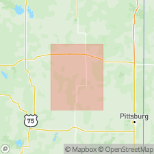
- Piqua limestone
- Modifications:
-
- Original reference
- Dominant lithology:
-
- Limestone
- AAPG geologic province:
-
- Cherokee basin
Summary:
Pg. 20. Piqua limestone. Heavy-bedded limestones, 50 feet thick, overlying Vilas shale and forming top formation exposed in Iola quadrangle. Age is Pennsylvanian. Report includes geologic map, general stratigraphic columnar section, fossil list.
[Named from Piqua, Woodson Co., southeastern KS.]
[†Piqua limestone member is same as Stanton limestone, older name.]
Source: US geologic names lexicon (USGS Bull. 896, p. 1671).
For more information, please contact Nancy Stamm, Geologic Names Committee Secretary.
Asterisk (*) indicates published by U.S. Geological Survey authors.
"No current usage" (†) implies that a name has been abandoned or has fallen into disuse. Former usage and, if known, replacement name given in parentheses ( ).
Slash (/) indicates name conflicts with nomenclatural guidelines (CSN, 1933; ACSN, 1961, 1970; NACSN, 1983, 2005, 2021). May be explained within brackets ([ ]).