

- Usage in publication:
-
- Pinyon Creek Conglomerate*
- Modifications:
-
- Named
- Reference
- Dominant lithology:
-
- Conglomerate
- AAPG geologic province:
-
- Wasatch uplift
Summary:
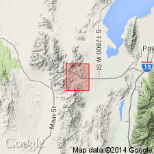
Named for exposures in lower reaches of Pinyon Creek Canyon in north-central part sec 35, T9S, R2W, Utah Co, UT on Wasatch uplift, its type locality. An equally conspicuous exposure found north of Pinyon Creek Canyon in RR cuts and tunnel, south-central part sec 26, T9S, R2W, considered a reference locality. Overlies Tintic Delmar Latite of Laguna Springs Volcanic Group; underlies Silver Shield Quartz Latite (all new names). Ranges in thickness from 0-1,000+ ft. Consists of lenses and beds of subangular to rounded pebbles, cobbles, and boulders interlayered with thin and thick beds of silt-, sand- and grit-sized volcanic debris. Most of the cobbles and boulders were derived from underlying Laguna Springs Volcanic Group, and only a few percent identified as fragments of Packard Quartz Latite or Paleozoic sedimentary rocks. Overall color is grayish tan, but some beds are uniformly reddish or purplish brown or drab gray. Characteristic feature is conspicuous bedding and great range in size of fragments. Beds are lense-like and cut downward into underlying units. Lenses range in thickness from 1 in-4 ft; thicker beds composed of cobbles and boulders. Within most beds rock fragments are well-sorted; some are less well sorted, and composed of chaotic mixtures of fragments. Not erosion-resistant; weathers into rounded boulder-strewn hills. Stratigraphic position indicates early Miocene age. Geologic map, measured sections.
Source: GNU records (USGS DDS-6; Denver GNULEX).
For more information, please contact Nancy Stamm, Geologic Names Committee Secretary.
Asterisk (*) indicates published by U.S. Geological Survey authors.
"No current usage" (†) implies that a name has been abandoned or has fallen into disuse. Former usage and, if known, replacement name given in parentheses ( ).
Slash (/) indicates name conflicts with nomenclatural guidelines (CSN, 1933; ACSN, 1961, 1970; NACSN, 1983, 2005, 2021). May be explained within brackets ([ ]).