The National Geologic Map Database is migrating to a new infrastructure. We apologize for any service disruptions during this process.
|
|---|


- Usage in publication:
-
- Pinnacles formation
- Modifications:
-
- Original reference
- Dominant lithology:
-
- Volcanic breccia
- Tuff
- Rhyolite
- AAPG geologic province:
-
- San Joaquin basin
Summary:
Pg. 19, 25, 26, map 1. Pinnacles formation. Volcanic breccias and tuffs, chiefly rhyolite. Age is Miocene (?).
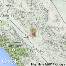
Named from exposures in Pinnacles National Monument, near King City, southeast of Salinas, west-central CA.
Source: US geologic names lexicon (USGS Bull. 1200, p. 3038).
- Usage in publication:
-
- Pinnacles Volcanics*
- Modifications:
-
- Redescribed
- Dominant lithology:
-
- Volcanics
- AAPG geologic province:
-
- California Coast Ranges province
Summary:
Pinnacles Formation of Andrews (1936) and Pinnacles Volcanic Formation of Matthews (1973, PhD thesis) is redescribed as Pinnacles Volcanics. Type section from Matthews (1973) is exposures along High Peaks Trail west of Chalone Peak campground, SW/4 SE/4 sec.35 to SW/4 SE/4 sec.34 T16S R7E, North Chalone Peak 7.5' quad, San Benito Co, CA. Primarily occurs in Pinnacles National Monument but several patches occur to north. Consists of calc-alkaline andesite, dacite, and rhyolite flows interbedded with pyroclastic and volcaniclastic rocks. Is at least 2185 m thick. Unconformably overlies Cretaceous granite rocks; unconformably underlies unnamed middle(?) Miocene shales. Age is early Miocene based on K-Ar determinations ranging from 23.9 +/-1.2 Ma to 21.5 +/-3.2 Ma.
Source: GNU records (USGS DDS-6; Menlo GNULEX).
For more information, please contact Nancy Stamm, Geologic Names Committee Secretary.
Asterisk (*) indicates published by U.S. Geological Survey authors.
"No current usage" (†) implies that a name has been abandoned or has fallen into disuse. Former usage and, if known, replacement name given in parentheses ( ).
Slash (/) indicates name conflicts with nomenclatural guidelines (CSN, 1933; ACSN, 1961, 1970; NACSN, 1983, 2005, 2021). May be explained within brackets ([ ]).