

- Usage in publication:
-
- Pine River quartzite conglomerate member
- Modifications:
-
- Named
- Dominant lithology:
-
- Conglomerate
- Quartzite
- AAPG geologic province:
-
- Lake Superior region
Summary:
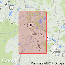
Is one of two "informally designated members of the Michigamme Slate, a formation in the Baraga Group of the Middle Precambrian Animikie Series of northern Michigan." Crops out south of Florence, Florence Co, WI (Lake Superior region) in the vicinity of Pine River Reservoir; apparently anomalous local quartz-rich body within thick sequence of typically "eugeosynclinal" chloritic slates, graywackes, and basic volcanic rocks. Formerly known as "Breakwater", [Breakwater Quartzite of Keith and others, 1935]. "The Pine River member consists of a lower meta-conglomerate, middle cross-stratified quartzite and pebbly quartzite, and upper meta-conglomerate, each of which thins to the northwest from a maximum total thickness of 600 feet to 150 feet in a distance of 3 miles. The conglomerate pebbles are elongate and consist predominantly of white and blue-gray recrystallized chert, interstratified chert and specularite, mosaic quartzite, and well-rounded strained vitreous quartz; the quartzose matrix contains variable amounts of specularite, magnetite, sericite-muscovite, biotite, chlorite, garnet and, locally, grunerite and chloritoid." Paleocurrent flow for both members is toward the southeast; both are thought to have been deposited in a shallow marine environment and derived from somewhat similar source rocks, but they cannot be correlated on a stratigraphic basis.
Source: GNU records (USGS DDS-6; Denver GNULEX).
For more information, please contact Nancy Stamm, Geologic Names Committee Secretary.
Asterisk (*) indicates published by U.S. Geological Survey authors.
"No current usage" (†) implies that a name has been abandoned or has fallen into disuse. Former usage and, if known, replacement name given in parentheses ( ).
Slash (/) indicates name conflicts with nomenclatural guidelines (CSN, 1933; ACSN, 1961, 1970; NACSN, 1983, 2005, 2021). May be explained within brackets ([ ]).