

- Usage in publication:
-
- Pilgrim Conglomerate Member
- Modifications:
-
- Named
- Dominant lithology:
-
- Tuff
- Conglomerate
- AAPG geologic province:
-
- Yellowstone province
Summary:
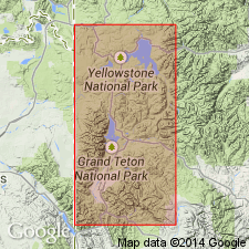
The Pilgrim Conglomerate Member. Name proposed for the upper member of Colter Formation. Exposed at Pilgrim Creek, Two Ocean Lake, Cunningham Hill, Shadow Mountain, and Ditch Creek, Teton County, Wyoming. The major vent area for the member was a few km northwest of Pilgrim Mountain. Consists of pink rhyolitic tuff, ignimbrite, and conglomerate, and differs from the underlying Crater Tuff Breccia Member (new) of the Colter by the occurrence of conglomerate, sandstone, and claystone, its pink, white, blue-gray, tan-gray, or green color, the presence of angular to subrounded volcanic clasts, and the frequent occurrence of rounded quartz cobbles. Is older than the Huckleberry Ridge Tuff. Thickness is 1,000 m. Age is Miocene. Was deposited between 13 and 9.4 Ma during later (extensional) volcanism. Report includes stratigraphic chart, measured sections, clast-size studies.
Type section (= upper part of Colter Formation type section): along Pilgrim Creek, Two Ocean Lake 7.5-minute quadrangle, Teton Co., WY (Yellowstone province). Named from Pilgrim Creek.
Source: US geologic names lexicon (USGS Bull. 1565, p. 249); GNU records (USGS DDS-6; Denver GNULEX).
- Usage in publication:
-
- Pilgrim Conglomerate Member
- Modifications:
-
- Overview
- AAPG geologic province:
-
- Yellowstone province
Summary:
Pg. 1453-1454. Pilgrim Conglomerate Member of Colter Formation. Middle Miocene (10.5 Ma to 16.0 Ma) deposits in the Greater Yellowstone region are confined to the Colter Formation of Jackson Hole, Teton County, Wyoming (Yellowstone province) and to Hepburn's Mesa Formation (new) of Yellowstone Valley, Park County, Montana (Montana folded belt province). The upper two-thirds of the Colter Formation, the Pilgrim Conglomerate Member, constitutes the Barstovian part of the section. Within it, calc-alkaline rhyolitic tuffs provide earliest evidence of extensional tectonic regimes in Jackson Hole. The Pilgrim Conglomerate Member is 1,000 m thick. Overlies 500 m of late Arikareean (ca. 24 Ma) through early Hemingfordian (ca. 18 Ma) Crater Tuff Breccia Member, lower member of the Colter. Early Barstovian strata may be represented by the 400 m of undated section that separate late Barstovian mammals from early Hemingfordian ones. The contact between the two members is covered and it probably coincides with a relatively short period of erosion. Age is middle Miocene (late Barstovian North American Land Mammal Age; probably not much younger than 13.6 Ma and not older than 14.8 Ma).
Source: Publication.
For more information, please contact Nancy Stamm, Geologic Names Committee Secretary.
Asterisk (*) indicates published by U.S. Geological Survey authors.
"No current usage" (†) implies that a name has been abandoned or has fallen into disuse. Former usage and, if known, replacement name given in parentheses ( ).
Slash (/) indicates name conflicts with nomenclatural guidelines (CSN, 1933; ACSN, 1961, 1970; NACSN, 1983, 2005, 2021). May be explained within brackets ([ ]).