The National Geologic Map Database is migrating to a new infrastructure. We apologize for any service disruptions during this process.
|
|---|


- Usage in publication:
-
- Piedmont Point Member
- Modifications:
-
- Named
- Dominant lithology:
-
- Breccia
- Pyroclastics
- AAPG geologic province:
-
- Blue Mountains province
- Snake River basin
Summary:
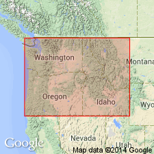
Named as member (one of two) of Doyle Creek Formation. Mapped in area between Wallowa Mountains in northeastern Oregon and Seven Devils Mountains of western Idaho (part of Snake River Canyon included). [Stratigraphic section of upper part of unit is included in type section of Doyle Creek Formation. Best exposed at Piedmont Point on east side of Snake River in sec.8 T22N R3W. Composed of volcanic flows and pyroclastic rocks of tuff breccia at least 600 ft thick. Conformably overlies Grassy Ridge Formation. Overlain and interlayered with Doyle Creek Formation.] Is Late Triassic age.
Source: GNU records (USGS DDS-6; Menlo GNULEX).
For more information, please contact Nancy Stamm, Geologic Names Committee Secretary.
Asterisk (*) indicates published by U.S. Geological Survey authors.
"No current usage" (†) implies that a name has been abandoned or has fallen into disuse. Former usage and, if known, replacement name given in parentheses ( ).
Slash (/) indicates name conflicts with nomenclatural guidelines (CSN, 1933; ACSN, 1961, 1970; NACSN, 1983, 2005, 2021). May be explained within brackets ([ ]).