

- Usage in publication:
-
- Picuris tuff
- Modifications:
-
- Named
- Dominant lithology:
-
- Tuff
- Gravel
- Conglomerate
- Clay
- Basalt
- AAPG geologic province:
-
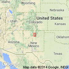
- San Luis basin
Summary:
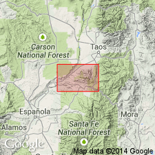
Named, probably for either Picuris re-entrant near towns of Badito and Placita, or Picuris Peak, Taos Co, NM, San Luis basin, where crops out. No type locality designated. Unconformably overlies Pennsylvanian Magdalena formation (revised); unconformably underlies Santa Fe formation (revised)--relation to Santa Fe is obscure. At Badito locality, about 1,000 ft crop out in one continuous section. At base are 680 ft of buff water-laid tuff interbedded with cemented gravel containing large percentage of pre-Cambrian material. Above lie 190 ft of salmon-pink, sandy clay with layers of cemented gravel containing many volcanic pebbles. These beds followed by 10 ft of giant conglomerate characterized by rounded boulders of pre-Cambrian quartzite and quartzose sandstone from Magdalena formation, having a maximum size of 4 ft. Above this conglomerate are 100 ft of gravel similar but with smaller pebbles and cobbles, capped by 40 ft of basaltic lava. Some gravel occurs above basalt, thickness unknown. About 2 mi east of this section, red and green silts and clays and a giant conglomerate, totaling 200 ft, belonging to the Picuris, rest unconformably on Magdalena. These beds lie below the tuff--so total thickness of Picuris in this area seems to be more than 1,200 ft. At other localities in area similar volcanic beds occur; their relation to Santa Fe is also obscure. Tentatively pre-Santa Fe, or earlier than middle Miocene to early Pliocene age.
Source: GNU records (USGS DDS-6; Denver GNULEX).
- Usage in publication:
-
- Picuris tuff
- Modifications:
-
- Revised
- AAPG geologic province:
-
- San Luis basin
Summary:
Picuris tuff revised--upper contact changed. Late Pliocene or earliest Pleistocene Servilleta formation (first used, this report) unconformably overlies both Santa Fe formation and Picuris tuff north of northeasterly and north-central borders of Picuris Range, Taos Co, NM, in San Luis basin. Age of Picuris tuff is probably Miocene.
Source: GNU records (USGS DDS-6; Denver GNULEX).
- Usage in publication:
-
- Picuris tuff
- Modifications:
-
- Not used
- AAPG geologic province:
-
- Estancia basin
Summary:
Pg. 118. Picuris tuff of Cabot (1938). Although Cabot (1938) extended Picuris tuff southward to include exposures just north of Santa Fe, Kottlowski is proposing name Bishops Lodge member of Tesuque formation for the 50 to 530 feet thick, light-gray volcanic-derived sandstone and silt, with minor tuff beds. In places rests conformably on as much as 100 feet of pinkish-tan Precambrian-derived sandstone typical of Tesuque formation. [See Spiegel and Baldwin, 1963, USGS Water-Supply Paper 1525].
Source: Publication; US geologic names lexicon (USGS Bull. 1200, p. 3009).
- Usage in publication:
-
- Picuris Tuff
- Modifications:
-
- Revised
- AAPG geologic province:
-
- Estancia basin
Summary:
Picuris Tuff revised--Spiegel and Baldwin (1963) assigned Bishop's Lodge as a member of Tesuque Formation, basal formation of Santa Fe Group; Bishop's Lodge is here removed from Tesuque and included in Picuris Tuff of Cabot (1938). Picuris Tuff crops out at widely separated points along the western border of the Sangre de Cristo Mountains north of Santa Fe, in Santa Fe Co, NM in Estancia basin. Gray tuff beds present in an area just west of the Bishop's Lodge-Santa Fe road had been described and mapped as basal part of Tesuque Formation [including Bishop's Lodge Member] by Spiegel and Baldwin (1963). In the present report, however, authors "believe the Bishop's Lodge Member to be a part of the Picuris Tuff of Cabot (1938), and...do not recognize a lithologic counterpart of the Bishop's Lodge Member in the Tesuque Formation. It is clear that the ultimate correlation of the Bishop's Lodge Member will remain for future investigators to decide."
Source: GNU records (USGS DDS-6; Denver GNULEX).
For more information, please contact Nancy Stamm, Geologic Names Committee Secretary.
Asterisk (*) indicates published by U.S. Geological Survey authors.
"No current usage" (†) implies that a name has been abandoned or has fallen into disuse. Former usage and, if known, replacement name given in parentheses ( ).
Slash (/) indicates name conflicts with nomenclatural guidelines (CSN, 1933; ACSN, 1961, 1970; NACSN, 1983, 2005, 2021). May be explained within brackets ([ ]).