The National Geologic Map Database is migrating to a new infrastructure. We apologize for any service disruptions during this process.
|
|---|


- Usage in publication:
-
- Petes Summit Formation
- Modifications:
-
- First used
- Biostratigraphic dating
- Dominant lithology:
-
- Argillite
- Quartzite
- AAPG geologic province:
-
- Great Basin province
Summary:
[Name "Petes Summit" used in diagram by Kay (1960)]. Petes Summit Formation listed as second from oldest formation (of 4) of Clipper Canyon Group. Consists of successive [informal] members of black argillite, quartz- and calc-arenite, lower orthoquartzite, quartz-silty and siliceous argillite, and upper orthoquartzite. Thickness is about 600 ft. Report includes list of graptolites and associated fossils of Arenigian, Llanvirnian and Llandeilian ages. [Based on 1983 DNAG Geologic Time scale, age is Early and Middle Ordovician].
Source: GNU records (USGS DDS-6; Menlo GNULEX).
- Usage in publication:
-
- Petes Summit Formation
- Modifications:
-
- Named
- Dominant lithology:
-
- Argillite
- Quartzite
- Shale
- AAPG geologic province:
-
- Great Basin province
Summary:
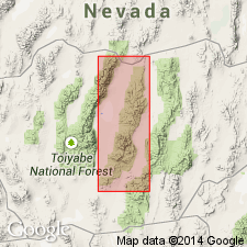
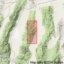
Named from Petes Summit, pass between Petes Canyon and tributary of Sams Canyon on Wilson Ranch-Frontier Road, Toquima Range, Lander Co, NV. Is second from oldest formation in Clipper Canyon Group (new). Shown on map of Petes Summit Sheet, Nye and Lander Cos, NV. Consists of 5 informal members: argillite with limestone and sandstone interbeds (about 200 ft thick), siliceous argillite (about 200 ft), lower quartzite (25 ft), upper siliceous shale (150 ft), and upper quartzite (30 ft). Total is about 600 ft. Overlies Charcoal Canyon Formation; underlies Sam Spring Formation (both new and of Clipper Canyon Group). Locally unconformably underlies Tertiary sedimentary and volcanic rocks. Age is Early and Middle Ordovician based on graptolites ranging in age from Arenigian to Llandeilian.
Source: GNU records (USGS DDS-6; Menlo GNULEX).
For more information, please contact Nancy Stamm, Geologic Names Committee Secretary.
Asterisk (*) indicates published by U.S. Geological Survey authors.
"No current usage" (†) implies that a name has been abandoned or has fallen into disuse. Former usage and, if known, replacement name given in parentheses ( ).
Slash (/) indicates name conflicts with nomenclatural guidelines (CSN, 1933; ACSN, 1961, 1970; NACSN, 1983, 2005, 2021). May be explained within brackets ([ ]).