

- Usage in publication:
-
- Perry Sand
- Modifications:
-
- Overview
- AAPG geologic province:
-
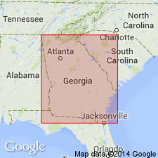
- South Georgia sedimentary province
Summary:
Perry Sand, named by Hetrick (1990), is prominently but thinly and delicately bedded, noncalcareous, nonfossiliferous, typically clean, well-sorted, incoherent, fine sand. Strata were previously included in the Gosport Sand. The Perry is assigned to the top of the Fort Valley Group (new). The type section is designated in this report at Perry, Houston Co., GA, where 25 ft (7.6 m) is exposed and unit overlies a lens of kaolin belonging to either the Oconee or Fort Valley Group. Elsewhere unit disconformably overlies the Marshallville Formation, Baker Hill Formation, or Tuscahoma Formation. Only locally disconformably underlies outliers of Barnwell Group. Unit occurs in a relatively narrow, northeast-southwest trending band, approximately 11 mi across, from the Ocmulgee River in Houston Co. in the east, westward through Randolph Co. May have been removed by erosion west of Randolph Co. and in AL. Grades eastward into the downdip Jeffersonville member of the Huber. Grades laterally updip into the Mossy Creek Sand. Grades seaward into the upper part of the Lisbon Formation. Middle Eocene (Bartonian, late Claibornian) age is based on stratigraphic position and correlation with the Blue Bluff Member of the Lisbon.
Source: GNU records (USGS DDS-6; Reston GNULEX).
- Usage in publication:
-
- Perry Sand
- Modifications:
-
- Overview
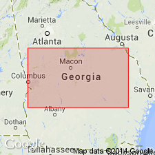
- Areal extent
- AAPG geologic province:
-
- South Georgia sedimentary province
Summary:
A distinctive formation west of the Ocmulgee River in GA, the Perry consists of stratified, relatively pure, well- to very well sorted, fine- to very fine grained quartz sand. Outcrop belt from Randolph Co. to Houston Co. is approximately 10 mi wide. May be present in the shallow subsurface east of the Ocmulgee, but there is no core data. In west-central GA, the Perry grades laterally updip into the Mossy Creek Sand, which is lithologically more variable. A Perry-like sand has been identified in four cores in eastern GA (Richmond, Jefferson, and northern Burke Cos). In western SC, there are two exposures of the Perry-like sand, one of which has been referred to the Huber Formation. Correlates with the middle Eocene Lisbon Formation to the south and occurs in the same stratigraphic position. Interpreted as a coastal marine lithofacies of the inner to middle neritic Lisbon.
Source: GNU records (USGS DDS-6; Reston GNULEX).
For more information, please contact Nancy Stamm, Geologic Names Committee Secretary.
Asterisk (*) indicates published by U.S. Geological Survey authors.
"No current usage" (†) implies that a name has been abandoned or has fallen into disuse. Former usage and, if known, replacement name given in parentheses ( ).
Slash (/) indicates name conflicts with nomenclatural guidelines (CSN, 1933; ACSN, 1961, 1970; NACSN, 1983, 2005, 2021). May be explained within brackets ([ ]).