The National Geologic Map Database is migrating to a new infrastructure. We apologize for any service disruptions during this process.
|
|---|


- Usage in publication:
-
- Perham formation
- Modifications:
-
- Original reference
- Dominant lithology:
-
- Siltstone
- Shale
- Conglomerate
- Slate
- AAPG geologic province:
-
- New England province
Summary:
Pg. 16 (table 2), 33, 40, pl. 1. Perham formation roughly approximates Ashland formation of previous workers. In present report formation is divided into two parts. Upper member contains orange-weathering commonly finely calcareous siltstone, gray shale, and limestone conglomerate lenses. Lower member contains gray, gray-red, and gray-green shale and slate; locally contains lenticular, layered iron and manganese deposits. Average thickness about 4,000 feet. Thickness 2,230 feet at type section. About 1,000 feet of upper member lies above upper part of measured section at type section. From east to west in Presque Isle quadrangle [this report], northeastern Maine, the Perham appears to be underlain successively by unnamed Silurian limestone, ribbon rock member of Meduxnekeag formation, Pyle Mountain argillite (new), and Frenchville formation (new). Underlies Hedgehog formation of Dockendorff group (new) in region east of Castle Hill area. Age is Silurian.
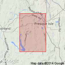
Type section: on Holster Blackstone farm in southwest part of Woodland Twp., 1.36 mi north of southern boundary of Twp., Caribou Co., northeastern ME. Section measured from east to west beginning 140 ft west of road 0.53 mi east of western boundary of Woodland Twp. [Derivation of name not stated in USGS Bull. 1350; uncertain if stated by authors. --unresolved.]
Source: US geologic names lexicon (USGS Bull. 1350, p. 568).
- Usage in publication:
-
- Perham Formation*
- Modifications:
-
- Overview
- Adopted
- Dominant lithology:
-
- Shale
- Silstone
- Limestone
- AAPG geologic province:
-
- New England province
Summary:
Pg. C32. Perham Formation. Consists mostly of shale and siltstone, minor amounts of limestone, and limestone breccia and lenticular ferruginous manganese deposits of sedimentary origin. Age is Late Silurian. Lower member is of Wenlock age and upper member is of early Ludlow age. (Perham Formation of Boucot and others (1964) is adopted for use in USGS reports.)
[GNC remark (ca. 1970, US geologic names lexicon, USGS Bull. 1350, p. 568): The USGS currently designates the age of the Perham Formation as Silurian on the basis of a study now in progress.]
Source: US geologic names lexicon (USGS Bull. 1350, p. 568); Changes in stratigraphic nomenclature, 1964 (USGS Bull. 1224-A, p. A8).
- Usage in publication:
-
- Perham Formation*
- Modifications:
-
- Revised
- AAPG geologic province:
-
- New England province
Summary:
Pg. A52-A57. Overlies Spragueville Formation (new).
Source: US geologic names lexicon (USGS Bull. 1350, p. 568).
For more information, please contact Nancy Stamm, Geologic Names Committee Secretary.
Asterisk (*) indicates published by U.S. Geological Survey authors.
"No current usage" (†) implies that a name has been abandoned or has fallen into disuse. Former usage and, if known, replacement name given in parentheses ( ).
Slash (/) indicates name conflicts with nomenclatural guidelines (CSN, 1933; ACSN, 1961, 1970; NACSN, 1983, 2005, 2021). May be explained within brackets ([ ]).