The National Geologic Map Database is migrating to a new infrastructure. We apologize for any service disruptions during this process.
|
|---|


- Usage in publication:
-
- Peppermill Gulf bed
- Modifications:
-
- Named
- Dominant lithology:
-
- Limestone
- AAPG geologic province:
-
- Appalachian basin
Summary:
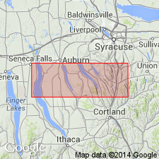
Peppermill Gulf bed is a newly recognized, fossil-rich horizon at the base of the Centerfield Member (and the correlative "Chenango facies") of the Ludlowville Formation. Overlies the Levanna Member of the Skaneateles Formation. Consists of a bioturbated, silty mudstone with a diverse assemblage of brachiopods, bivalves, and some rugose corals. Outcrops extend from Big Hollow Creek on the west side of Cayuga Lake to Case Hill Ravine south of Syracuse. Age is Middle Devonian.
Source: GNU records (USGS DDS-6; Reston GNULEX).
For more information, please contact Nancy Stamm, Geologic Names Committee Secretary.
Asterisk (*) indicates published by U.S. Geological Survey authors.
"No current usage" (†) implies that a name has been abandoned or has fallen into disuse. Former usage and, if known, replacement name given in parentheses ( ).
Slash (/) indicates name conflicts with nomenclatural guidelines (CSN, 1933; ACSN, 1961, 1970; NACSN, 1983, 2005, 2021). May be explained within brackets ([ ]).