The National Geologic Map Database is migrating to a new infrastructure. We apologize for any service disruptions during this process.
|
|---|


- Usage in publication:
-
- Pencil Cave Metabentonite
- Modifications:
-
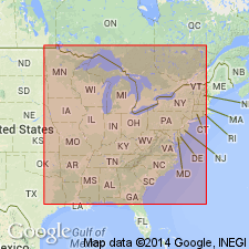
- Areal extent
- Overview
Summary:
Blackriveran Deicke Metabentonite of MO is "junior synonym" for Pencil Cave Metabentonite and is therefore abandoned. Pencil Cave occurs at the base of the upper Tyrone of KY, in the upper Carters of TN, AL, and GA, and near the base of the Castlewood Member (reallocated) of the Plattin in MO. Pencil Cave has also been identified in the upper Lowville Formation in NY. It does not occur in MN, IA, and WI as the upper Lowville part of the Black River Group is missing in those states.
Source: GNU records (USGS DDS-6; Reston GNULEX).
- Usage in publication:
-
- Pencil Cave metabentonite
GNU Staff, 1996, GNU Staff remark. Pencil Cave Metabentonite.: U.S. Geological Survey Digital Data Series, DDS-6, 1 CD-ROM., release 3
Summary:
Pencil Cave originated as a descriptive term applied by drillers to certain clay or shale formations, which "cave" in drilling and which have a tendency to break up easily into long pencil-like forms. The name has been applied in western Pennsylvania to beds, 5 to 40 feet thick, in midst of Mauch Chunk Shale or Greenbrier Limestone and in West Virginia to the Lillydale Shale. The Pencil Cave of drillers of central Tennessee (Crossville region) is a volcanic ash (bentonite) of Ordovician age, lying near boundary between limestones of Trenton and Black River age. This last is usage which Conkin has extended to several states.
[According to GNU records (USGS DDS-6), unit is considered informal.]
Source: GNU records (USGS DDS-6; Reston GNULEX).
For more information, please contact Nancy Stamm, Geologic Names Committee Secretary.
Asterisk (*) indicates published by U.S. Geological Survey authors.
"No current usage" (†) implies that a name has been abandoned or has fallen into disuse. Former usage and, if known, replacement name given in parentheses ( ).
Slash (/) indicates name conflicts with nomenclatural guidelines (CSN, 1933; ACSN, 1961, 1970; NACSN, 1983, 2005, 2021). May be explained within brackets ([ ]).