

- Usage in publication:
-
- Pecos formation*
- Modifications:
-
- Original reference
- AAPG geologic province:
-
- Permian basin
Summary:
Pecos formation. A lithologic unit consisting chiefly of red beds, gypsum, anhydrite, impure limestone, light-colored fine sand, and intercalated thin beds of magnesian or dolomitic limestone and dolomite. Unconformably underlies the Triassic east of Pecos River and overlies Picacho limestone, with unconformity locally. Base of formation varies considerably in stratigraphic position, being lower north of Salt Creek and notably higher a few miles south of mouth of Seven Rivers than it is within the artesian basin. Near top, in Seven Rivers region, it is penetrated laterally by Carlsbad limestone tongue of Capitan limestone, which is underlain by Seven Rivers tongue of Pecos formation, which to south becomes replaced laterally by Capitan limestone. Upper part of Pecos formation has been eroded away west of Pecos River, but lower part extends a few miles west of river. Thickness of formation 1,066 feet in one section. The strata constituting the Pecos formation are represented on Darton's 1928 geologic map of New Mexico as Chupadera formation north of Lake McMillan and as Castile formation southeast of Lake McMillan. The beds here named Picacho limestone are believed by geologists working in this region to be stratigraphic equivalent of San Andres limestone of Lee and Girty, and have been referred to by that name for years. Age is Permian.
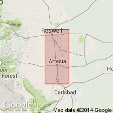
Named from exposures east of Pecos River, [Chaves and Eddy Cos.], Roswell artesian basin, southeastern NM.
Source: US geologic names lexicon (USGS Bull. 896, p. 1623).
- Usage in publication:
-
- Pecos formation†
- Modifications:
-
- Abandoned
- AAPG geologic province:
-
- Permian basin
Summary:
†Pecos formation abandoned, being here divided into (descending): Pierce Canyon red beds, Rustler formation, Salado halite, Castile anhydrite (thin lateral extension of upper part of Castile anhydrite of Delaware basin), and Chalk Bluff formation. Latter formation includes equivalents of (descending) Seven River gypsiferous member, Queen sandstone member and underlying beds that are = Dog Canyon limestone. Picacho limestone is here abandoned for San Andres limestone. The Pierce Canyon redbeds are now classified as Triassic.
Source: US geologic names lexicon (USGS Bull. 896, p. 1623).
For more information, please contact Nancy Stamm, Geologic Names Committee Secretary.
Asterisk (*) indicates published by U.S. Geological Survey authors.
"No current usage" (†) implies that a name has been abandoned or has fallen into disuse. Former usage and, if known, replacement name given in parentheses ( ).
Slash (/) indicates name conflicts with nomenclatural guidelines (CSN, 1933; ACSN, 1961, 1970; NACSN, 1983, 2005, 2021). May be explained within brackets ([ ]).