The National Geologic Map Database is migrating to a new infrastructure. We apologize for any service disruptions during this process.
|
|---|


- Usage in publication:
-
- Parguera Limestone*
- Modifications:
-
- Revised
- AAPG geologic province:
-
- Caribbean region
Summary:
The Parguera Limestone of Mattson (1960) is here adopted. Mapped by Slodowski (1958) as the andesite member of the "Ensenada Formation". Members of Almy (1965) are not noted.
Source: GNU records (USGS DDS-6; Reston GNULEX).
- Usage in publication:
-
- Parguera Limestone*
- Modifications:
-
- Revised
- Areal extent
- AAPG geologic province:
-
- Caribbean region
Summary:
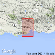
Parguera Limestone is here restricted to the area south of the Lajas Valley because rocks mapped by Mattson (1960) as Parguera north of the Lajas Valley are lithologically different from the type Parguera. The Parguera is divided into an informal lower member, which includes Almy's Bahia Fosforescente and Punta Papaya Members of late Santonian to late Campanian age, and an informal upper member, which includes Almy's Isla Magueyes Member of late Campanian to early Maastrichtian age.
Source: GNU records (USGS DDS-6; Reston GNULEX).

- Usage in publication:
-
- Parguera Limestone*
- Modifications:
-
- Overview
- AAPG geologic province:
-
- Caribbean region
Summary:
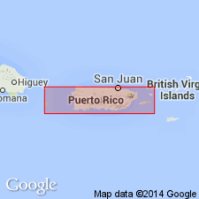
The Parguera Limestone occurs in southwestern Puerto Rico and consists of a basal conglomerate that grades upward into limestone. Limestone in the upper part is composed of varied, coarse, skeletal clasts of fossils. Maximum estimated thickness is 1000 meters. The Parguera is of Late Cretaceous age.
Source: GNU records (USGS DDS-6; Reston GNULEX).
For more information, please contact Nancy Stamm, Geologic Names Committee Secretary.
Asterisk (*) indicates published by U.S. Geological Survey authors.
"No current usage" (†) implies that a name has been abandoned or has fallen into disuse. Former usage and, if known, replacement name given in parentheses ( ).
Slash (/) indicates name conflicts with nomenclatural guidelines (CSN, 1933; ACSN, 1961, 1970; NACSN, 1983, 2005, 2021). May be explained within brackets ([ ]).