The National Geologic Map Database is migrating to a new infrastructure. We apologize for any service disruptions during this process.
|
|---|


- Usage in publication:
-
- Paiute formation*
- Modifications:
-
- Original reference
- Dominant lithology:
-
- Gravel
- AAPG geologic province:
-
- Great Basin province
Summary:
Pg. D111. Paiute formation. Consists of at least 40 feet of alluvial and colluvial gravel. Overlies andesitic and basaltic lavas of Pliocene and early Pleistocene(?) age with pronounced unconformity; underlies pre-Lake Lahontan soil and earliest deposits of Lake Lahontan (Eetza formation, new) with slight or no disconformity. Age is late Pleistocene.
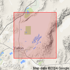
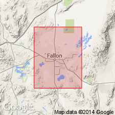
Type locality: exposure along middle part of Paiute Wash, in sec. 8, T. 16 N., R. 31 E., near Fallon, Churchill Co., southern NV. Named from Paiute Wash. Exposed locally, above 3,960 ft altitude, on piedmonts and in highlands.
Source: US geologic names lexicon (USGS Bull. 1350, p. 551).
- Usage in publication:
-
- Paiute Formation*
- Modifications:
-
- Adopted
- AAPG geologic province:
-
- Great Basin province
Summary:
Pg. 23-24. Paiute Formation. Bulk of unit is alluvial-fan gravel exposed above 3,960 feet elevation. Overlies Bunejug formation (new) and older rocks with pronounced unconformity. Conformably underlies Cocoon soil which in turn underlies Eetza formation. Shown on geologic maps of Carson Lake and Fallon 15-min quadrangles as of Pleistocene age. Is youngest sedimentary unit of pre-Lake Lahontan age.
Type locality: Paiute Wash, in sec. 8, T. 16 N., R. 31 E., on piedmont northeast of Cocoon Mountains, Churchill Co., southern NV.
Source: US geologic names lexicon (USGS Bull. 1350, p. 551); GNU records (USGS DDS-6; Menlo GNULEX).
- Usage in publication:
-
- Paiute Alloformation
- Modifications:
-
- Redescribed
- Reference
- AAPG geologic province:
-
- Great Basin province
Summary:
Paiute Formation of Morrison (1961) redescribed as Paiute Alloformation as defined in 1983 North American Stratigraphic Code.
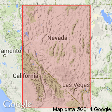
Reference locality: in Wadsworth Amphitheatre, in E/2 sec. 15, T. 21 N., R. 24 E., Wadsworth 15-min quadrangle, Washoe Co., southern NV.
Source: Modified from GNU records (USGS DDS-6; Menlo GNULEX).
For more information, please contact Nancy Stamm, Geologic Names Committee Secretary.
Asterisk (*) indicates published by U.S. Geological Survey authors.
"No current usage" (†) implies that a name has been abandoned or has fallen into disuse. Former usage and, if known, replacement name given in parentheses ( ).
Slash (/) indicates name conflicts with nomenclatural guidelines (CSN, 1933; ACSN, 1961, 1970; NACSN, 1983, 2005, 2021). May be explained within brackets ([ ]).