

- Usage in publication:
-
- Otter Creek shale
- Modifications:
-
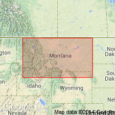
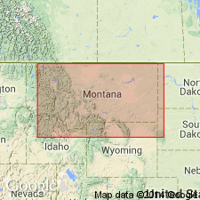
- Areal extent
- Dominant lithology:
-
- Shale
- Limestone
- AAPG geologic province:
-
- Sweetgrass arch
Weed, W.H., 1892, Two Montana coal fields: Geological Society of America Bulletin, v. 3, p. 301-330.
Summary:
Pg. 307. Published a detailed section on Belt Creek, central northern Montana, in which he gave following succession in lower part: (1) conglomerate and sandstone containing Jurassic fossils, 215 feet; (2) white limestone, red earthy patches, Paleozoic facies, 90 feet; (3) Otter Creek shales (alternating gray, purple, green, and black shales and earthy limestones yielding Carboniferous fossils), 212 feet; (4) black chert belt, 8 feet; (5) limestones and shales, 80 feet; (6) gypsum, 3 feet.
Source: US geologic names lexicon (USGS Bull. 896, p. 1575).
- Usage in publication:
-
- Otter shale*
- Modifications:
-
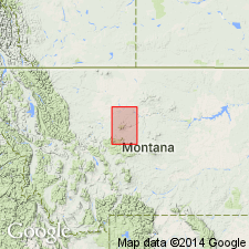
- Areal extent
- Dominant lithology:
-
- Shale
- Limestone
- AAPG geologic province:
-
- Sweetgrass arch
Summary:
Otter shale [= Otter Creek shales (Weed, 1892)]. In this quadrangle lowest beds of Quadrant formation are the gypsiferous Kibbey sandstone, which is overlain by Otter shales, the upper member of the Quadrant, consisting of 303 feet of dark-gray or purplish shales near base, becoming a bright coppery-green color higher up, and interbedded with limestones, the latter seldom more than 1 or 2 feet thick, frequently oolitic, and carrying lower Carboniferous fossils. Assigned to Carboniferous. The Otter shale is overlain by Ellis formation.
[Quadrant formation is mapped over large area along Little Otter Creek, down to near where it flows into Otter Creek, in Fort Benton quadrangle.]
Source: US geologic names lexicon (USGS Bull. 896, p. 1575).
- Usage in publication:
-
- Otter formation
- Modifications:
-
- Revised
- AAPG geologic province:
-
- Central Montana uplift
Summary:
Pg. 1027-1028; GSA Proc. 1934, p. 367. Otter Formation included in Big Snowy group (new). [Age is Late Mississippian.]
Source: US geologic names lexicon (USGS Bull. 1200, p. 2871).

- Usage in publication:
-
- Otter shale member*
- Modifications:
-
- Adopted
- AAPG geologic province:
-
- Central Montana uplift
- Sweetgrass arch
Summary:
The USGS adopted Otter shale member of Quadrant formation in 1907. Recognized in Great Falls-Fort Benton region, central northern Michigan. Age is Late Mississippian.
See entry under Scott (1935), who treats this as basal formation of his Big Snowy group.
Source: US geologic names lexicon (USGS Bull. 896, p. 1575).
- Usage in publication:
-
- Otter formation*
- Modifications:
-
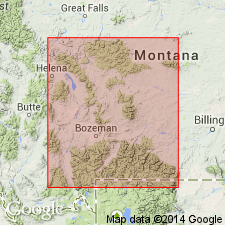
- Areal extent
- AAPG geologic province:
-
- Central Montana uplift
Summary:
Is one of six formations assigned to Big Snowy group (which formerly included only three formations). Overlies Kibbey sandstone, basal formation of Big Snowy; underlies Heath formation of Big Snowy. Measured section 374 ft thick at T11N, Rs20 and 21E in Golden Valley and Musselshell Cos, MT on the Central Montana uplift described. Cross sections. Nomenclature chart. In measured section, consists of interbedded gray to green shale; gray, white to brown limestone; gray to green siltstone; and claystone. Has one thin sandstone that is yellow brown, calcareous, poorly sorted and clayey. The limestone beds range from fine to medium crystalline, dense, porous, wavy laminated. Of Late Mississippian age.
Source: GNU records (USGS DDS-6; Denver GNULEX).
- Usage in publication:
-
- Otter Formation*
- Modifications:
-
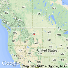
- Areal extent
- AAPG geologic province:
-
- Central Montana uplift
- Powder River basin
- Williston basin
Summary:
Is middle formation of revised Big Snowy Group, a group restricted to Kibbey, Otter, and Heath Formations, all of Chester, or Late Mississippian age. Is 374 ft thick at reference section of Amsden Group. Is 375 to 475 ft thick in Big Snowy Mountains, about 225 ft thick in Williston basin, and 198 ft thick in Little Belt Mountains. Fossils indicate a marine environment of deposition. Areal limits in Williston and Powder River basins, Central Montana uplift, shown on map. Fossil chart. Cross sections. Measured sections. Correlation chart.
Source: GNU records (USGS DDS-6; Denver GNULEX).
For more information, please contact Nancy Stamm, Geologic Names Committee Secretary.
Asterisk (*) indicates published by U.S. Geological Survey authors.
"No current usage" (†) implies that a name has been abandoned or has fallen into disuse. Former usage and, if known, replacement name given in parentheses ( ).
Slash (/) indicates name conflicts with nomenclatural guidelines (CSN, 1933; ACSN, 1961, 1970; NACSN, 1983, 2005, 2021). May be explained within brackets ([ ]).