The National Geologic Map Database is migrating to a new infrastructure. We apologize for any service disruptions during this process.
|
|---|


- Usage in publication:
-
- Onion Creek Formation*
- Modifications:
-
- Named
- Dominant lithology:
-
- Limestone
- Quartzite
- AAPG geologic province:
-
- Sierra Nevada province
Summary:
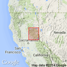
Name derived from Onion Creek. Type locality designated as exposures in Onion Creek, SE/4 sec.11 T16N R14E, Norden 7.5' quad [Placer Co, CA]. Is part of Lake Tahoe sequence. Also occurs east of Serena Creek and at confluence of Serena Creek and North Fork of American River. Composed of interbedded calc-silicate rock, limestone, and black pelite. Maximum thickness at type locality is 400 m. Gradationally overlies Serena Creek Formation (new); top unknown as intruded by granitic rocks of Sierra Nevada batholith. Age considered [tentatively] Mississippian(?) and younger(?) based on stratigraphic relations. Brachiopod(?) fragment found in lowermost part of unit.
Source: GNU records (USGS DDS-6; Menlo GNULEX).
For more information, please contact Nancy Stamm, Geologic Names Committee Secretary.
Asterisk (*) indicates published by U.S. Geological Survey authors.
"No current usage" (†) implies that a name has been abandoned or has fallen into disuse. Former usage and, if known, replacement name given in parentheses ( ).
Slash (/) indicates name conflicts with nomenclatural guidelines (CSN, 1933; ACSN, 1961, 1970; NACSN, 1983, 2005, 2021). May be explained within brackets ([ ]).