The National Geologic Map Database is migrating to a new infrastructure. We apologize for any service disruptions during this process.
|
|---|


- Usage in publication:
-
- Omen member
- Modifications:
-
- Principal reference
- AAPG geologic province:
-
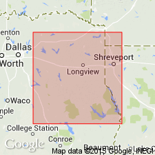
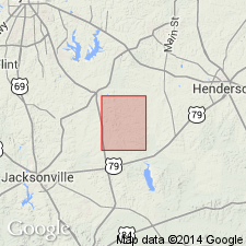
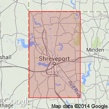
- East Texas basin
Summary:
Pg. 1355-1356. Omen member. A local greensand member of Queen City member of Mount Selman formation. Lies approximately 140 feet above the main glauconite of the Reklaw and between 240 and 280 feet below top of the Weches. Well exposed near Omen and Arp, in eastern Smith County, northeastern Texas, and is here term Omen from the communit where it was first recognized. The greensand extends from Harrison, through Gregg, northwestern Rusk, and eastern Smith Counties, into Cherokee County, northeastern Texas. It consists of 10 to 15 feet of partly cross-bedded mealy, sandy glauconite, which weathers rapidly and is difficult to recognized. The best ores are found in Omen member. [Age is middle Eocene.]
Source: US geologic names lexicon (USGS Bull. 896, p. 1546).
- Usage in publication:
-
- Omen member
- Modifications:
-
- Revised
- AAPG geologic province:
-
- East Texas basin
Summary:
Pg. 538, 542. Reklaw as defined by Wendlandt and Knebel the writer considers as basal Claiborne of Texas and that it properly includes the Omen member, which they assigned to Queen City sand. [Age is middle Eocene.]
Source: US geologic names lexicon (USGS Bull. 896, p. 1546).

- Usage in publication:
-
- Omen greensand member
- Modifications:
-
- Overview
- AAPG geologic province:
-
- East Texas basin
Summary:
Pg. 630. Omen greensand member was named by MacNaughton (private rpt. written for Humble Oil and Refining Company, Feb. 10, 1929). The name was published by Wendlandt and Knebel, 1929. It is middle member of Queen City formation. [Age is middle Eocene.]
Source: US geologic names lexicon (USGS Bull. 896, p. 1546).
- Usage in publication:
-
- Omen glauconitic sandstone member
- Modifications:
-
- Areal extent
- AAPG geologic province:
-
- Gulf Coast basin
Summary:
Pg. 10 (fig. 3), 95-99, 110, 113, pl. 1. Omen glauconitc sandstone member of Queen City formation. Described in Henry Chapel quadrangle, eastern Texas, as glauconitc sandstone member of Queen City formation. Thickness 22 feet. Underlies an unnamed sand member; overlies Arp member. [Age is middle Eocene.]
Source: US geologic names lexicon (USGS Bull. 1200, p. 2826).
- Usage in publication:
-
- Omen member
- Modifications:
-
- Areal extent
- AAPG geologic province:
-
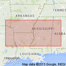
- Arkla basin
Summary:
Pg. 2520. Omen member of Queen City formation. Geographically extended into Caddo Parish, northwestern Louisiana, where it is about 22 feet thick. Overlies Arp member; underlies Mytis sand member (new). [Age is middle Eocene.]
Source: US geologic names lexicon (USGS Bull. 1200, p. 2826).
For more information, please contact Nancy Stamm, Geologic Names Committee Secretary.
Asterisk (*) indicates published by U.S. Geological Survey authors.
"No current usage" (†) implies that a name has been abandoned or has fallen into disuse. Former usage and, if known, replacement name given in parentheses ( ).
Slash (/) indicates name conflicts with nomenclatural guidelines (CSN, 1933; ACSN, 1961, 1970; NACSN, 1983, 2005, 2021). May be explained within brackets ([ ]).