The National Geologic Map Database is migrating to a new infrastructure. We apologize for any service disruptions during this process.
|
|---|


- Usage in publication:
-
- Oljato sandstone member
- Modifications:
-
- Named
- Dominant lithology:
-
- Sandstone
- AAPG geologic province:
-
- Paradox basin
Summary:
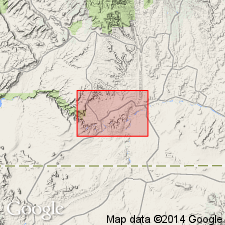
Named and tentatively assigned to the Moencopie formation as its upper member. Consists of massive, brown, slightly ferruginous, cross-bedded lenticular sandstone. Increases in thickness from northeast to southwest. In northwest corner of the San Juan field, UT in the Paradox basin, it is 20 ft thick. Is 175 ft thick at Navajo rock, and 382 ft thick at Moses Rock. Is present in Canyon de Chelly and at Oljato, and it is prominent in northeast AZ. Contains fossilized wood, charcoal, and plant fossils. Geologic map; cross sections. Mapped in a northeast-trending band on east side of map above unnamed part of Moencopie and below Dolores shale. Of Permian? age.
Source: GNU records (USGS DDS-6; Denver GNULEX).
For more information, please contact Nancy Stamm, Geologic Names Committee Secretary.
Asterisk (*) indicates published by U.S. Geological Survey authors.
"No current usage" (†) implies that a name has been abandoned or has fallen into disuse. Former usage and, if known, replacement name given in parentheses ( ).
Slash (/) indicates name conflicts with nomenclatural guidelines (CSN, 1933; ACSN, 1961, 1970; NACSN, 1983, 2005, 2021). May be explained within brackets ([ ]).