The National Geologic Map Database is migrating to a new infrastructure. We apologize for any service disruptions during this process.
|
|---|


- Usage in publication:
-
- Ogo Member
- Modifications:
-
- Named
- Dominant lithology:
-
- Sandstone
- Mudstone
- Conglomerate
- AAPG geologic province:
-
- Sacramento basin
Summary:
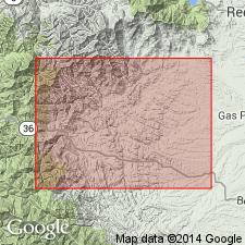
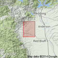
Named as 2nd from lowermost member (of 7) of Budden Canyon Formation (new). Name derived from Ogo Station in northwest part of Ono 15' quad. Reference section designated along Budden Canyon from contact with Rector Conglomerate Member in secs.35-36 T29N R8W to sandstone units of Roaring River Member sec.1 T28N R8W, Ono 15'quad, Tehama Co, CA. Name applied to beds between Rector Conglomerate Member (or basement contact where conglomerate is absent) and Roaring River Member. Includes thick-bedded sandstones (50 to 200 ft), mudstones with concretionary limestone (50 to several 100 ft), thin- to medium-bedded sandstones with slightly thicker beds of mudstone (up to 9000 ft), and locally conglomerates. Total thickness nearly 10,000 ft in Budden Canyon-Dry Creek section. Age is Cretaceous.
Source: GNU records (USGS DDS-6; Menlo GNULEX).
- Usage in publication:
-
- Ogo Member
- Modifications:
-
- Age modified
- AAPG geologic province:
-
- Sacramento basin
Summary:
Age of Ogo Member is Hauterivian based on ammonites, pelecypods, and gastropods, some of which are listed. Other fossils including plant remains have been collected. Shown on geologic map of portions of Ono and Chanchelulla Peak 15' quads. Underlies Roaring River Member (Budden Canyon Formation). Locally conformably overlies Rector Member (Budden Canyon Formation). Also unconformably overlies Abrams Mica Schist and Salmon Hornblende Schist (mapped as single unit), Bragdon(?) Formation, Jurassic to Cretaceous serpentine, and Shasta Bally Batholith.
Source: GNU records (USGS DDS-6; Menlo GNULEX).
For more information, please contact Nancy Stamm, Geologic Names Committee Secretary.
Asterisk (*) indicates published by U.S. Geological Survey authors.
"No current usage" (†) implies that a name has been abandoned or has fallen into disuse. Former usage and, if known, replacement name given in parentheses ( ).
Slash (/) indicates name conflicts with nomenclatural guidelines (CSN, 1933; ACSN, 1961, 1970; NACSN, 1983, 2005, 2021). May be explained within brackets ([ ]).