

- Usage in publication:
-
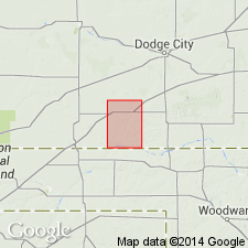
- Odee formation
- Modifications:
-
- Overview
- AAPG geologic province:
-
- Anadarko basin
Summary:
Consists of beds chiefly or entirely younger than Crooked Creek formation (new). Type locality here designated as exposures in sec 35, T34S, R29W, Cimarron Township, Meade Co, KS in the Anadarko basin. Odee, at type, has abundant ostracods and gastropods, and a few poorly preserved vertebrates. Odee formation restricted to the scattered deposits of basin filling of local origin. Consists of red clay and silt containing selenite crystals and blue to blue-gray gastropod-bearing silt and clay. Probably derived from Permian rocks. Skull of CITELLUS RICHARDSONII (Sabine) indicates late Pleistocene age. Other vertebrate fossils found. Stratigraphic chart.
Source: GNU records (USGS DDS-6; Denver GNULEX).
For more information, please contact Nancy Stamm, Geologic Names Committee Secretary.
Asterisk (*) indicates published by U.S. Geological Survey authors.
"No current usage" (†) implies that a name has been abandoned or has fallen into disuse. Former usage and, if known, replacement name given in parentheses ( ).
Slash (/) indicates name conflicts with nomenclatural guidelines (CSN, 1933; ACSN, 1961, 1970; NACSN, 1983, 2005, 2021). May be explained within brackets ([ ]).