The National Geologic Map Database is migrating to a new infrastructure. We apologize for any service disruptions during this process.
|
|---|


- Usage in publication:
-
- Occohannock Member*
- Modifications:
-
- Named
- Dominant lithology:
-
- Sand
- AAPG geologic province:
-
- Atlantic Coast basin
Summary:
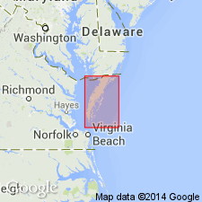
Light yellowish-gray, fine to medium quartz sand surficial beds on the Franktown plain are here named the Occohannock Member of the Nassawadox Formation. Disconformably overlies the Accomack Member of the Omar Formation to the north; conformably overlies the Butlers Bluff Member of the Nassawadox to the southwest. Thickness at type section is 15 ft (4.5 m). Age is Pleistocene.
Source: GNU records (USGS DDS-6; Reston GNULEX).

- Usage in publication:
-
- Occohannock Member
- Modifications:
-
- Overview
- AAPG geologic province:
-
- Atlantic Coast basin
Summary:
Nomenclature on State map follows Mixon (1985). Occohannock Member is upper member of Nassawadox Formation. Mapped east of Chesapeake Bay. It is described here as light-yellowish-gray, fine to medium sand underlying southwest-sloping terrace on west side of upland. Sand is dominantly massive to horizontally bedded, but shows some small-scale cross-bedding. Locally, unit contains clay and silt as matrix and thin beds. Deposited in a low-energy, open-bay environment. Thickness ranges from a featheredge near bay-facing scarp along western margin of upland to 20 ft in downdip areas near present bay. Overlies Butlers Bluff Member. Age is late Pleistocene.
Source: GNU records (USGS DDS-6; Reston GNULEX).
For more information, please contact Nancy Stamm, Geologic Names Committee Secretary.
Asterisk (*) indicates published by U.S. Geological Survey authors.
"No current usage" (†) implies that a name has been abandoned or has fallen into disuse. Former usage and, if known, replacement name given in parentheses ( ).
Slash (/) indicates name conflicts with nomenclatural guidelines (CSN, 1933; ACSN, 1961, 1970; NACSN, 1983, 2005, 2021). May be explained within brackets ([ ]).