

- Usage in publication:
-
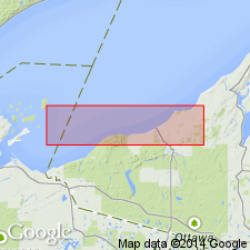
- Oak Bluff Formation
- Modifications:
-
- First used
- Dominant lithology:
-
- Andesite
- Felsite
- AAPG geologic province:
-
- Michigan basin
Summary:
Oak Bluff Formation formerly referred to as Unnamed Formation. Oldest rock unit in study area. Has been separated into series of andesite flows and one or more felsic flows. Contains some interflow sediments, principally sandy conglomerate with pebbles and cobbles less than 4 in., but some boulders of 3 ft. Andesite flows total 2,000 ft. Felsite flow(s) measure 500 ft in thickness and form core of Porcupine Mountains. Underlies Copper Harbor Conglomerate. Age is Middle Proterozoic (middle Keweenawan).
Source: GNU records (USGS DDS-6; Reston GNULEX).
- Usage in publication:
-
- Oak Bluff Formation
- Modifications:
-
- Overview
- AAPG geologic province:
-
- Michigan basin
Summary:
Oak Bluff Formation overlies the Portage Lake Volcanics. It differs from the latter in that the Oak Bluff flows are more felsic in composition. It consists of basalts, andesites, felsites, and quartz-feldspar porphyries. Contains interflow conglomerates, sandstones, and siltstones . South of White Pine, the Oak Bluff is about 2,440 m thick. Thickness decreases east and west, terminating to the northeast in the Mass-Greenland area and west near the Wisconsin border. Underlies and may locally intertongue with the Copper Harbor Conglomerate. Age is Middle Proterozoic.
Source: GNU records (USGS DDS-6; Reston GNULEX).
For more information, please contact Nancy Stamm, Geologic Names Committee Secretary.
Asterisk (*) indicates published by U.S. Geological Survey authors.
"No current usage" (†) implies that a name has been abandoned or has fallen into disuse. Former usage and, if known, replacement name given in parentheses ( ).
Slash (/) indicates name conflicts with nomenclatural guidelines (CSN, 1933; ACSN, 1961, 1970; NACSN, 1983, 2005, 2021). May be explained within brackets ([ ]).