

- Usage in publication:
-
- Nottely quartzite*
- Modifications:
-
- Named
- Dominant lithology:
-
- Quartzite
- AAPG geologic province:
-
- Piedmont-Blue Ridge province
Summary:
Nottely quartzite (new name), overlying the Andrews schist, is composed entirely of fine white quartzite. It has a thickness of more than 150 ft. Highest Cambrian formation in the area.
Source: GNU records (USGS DDS-6; Reston GNULEX).
- Usage in publication:
-
- Nottely quartzite*
- Modifications:
-
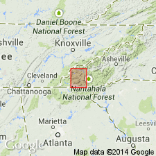
- Overview
- Areal extent
- AAPG geologic province:
-
- Piedmont-Blue Ridge province
Summary:
Nottely quartzite is thin but prominent ridge-making quartzite that occurs in contact with Murphy marble only in main belt from Ellijay, GA, northeastward. From Mineral Bluff, GA, northeastward to Tomotla, NC, it is exposed continuously for more than 24 mi. Quartzite dips steeply southeast to vertical. In places it is folded with the marble, but for most part it lies southeast of the marble and northeast of Valleytown formation. Where Nottely quartzite is not present and Murphy marble lies adjacent to Valleytown formation, as in Tate area, GA, it is assumed that the Nottely is absent because of nondeposition. Locally in Murphy syncline, the Nottely is cut out by faults and in some areas is in fault contact with Nantahala slate and Great Smoky quartzite.
Source: GNU records (USGS DDS-6; Reston GNULEX).
- Usage in publication:
-
- Nottely Quartzite Member
- Modifications:
-
- Revised
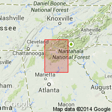
- Areal extent
- AAPG geologic province:
-
- Piedmont-Blue Ridge province
Summary:
Nottely Quartzite is redefined here as a member of the Mineral Bluff Formation. Unit is about 45 m thick at Murphy and consists of thick to thin bedded, coarse to fine grained, locally cross-bedded feldspathic metasandstone. Authors have recognized the Nottely as far south as the Ball Ground West quad. and have also found it on both limbs of the Murphy syncline. Occurs at or near the base of the Mineral Bluff. At some localities, metapelites of the undifferentiated Mineral Bluff that occur below the Nottely have been assigned to the Andrews Formation. Where Nottely occurs at base of Mineral Bluff, overlies Andrews (near Murphy), Murphy Marble (near Mineral Bluff and Blue Ridge), Brasstown Formation (at Cherry Log and south), or the uppermost Great Smoky Group (near Jasper).
Source: GNU records (USGS DDS-6; Reston GNULEX).
- Usage in publication:
-
- Nottely Quartzite Member
- Modifications:
-
- Revised
- AAPG geologic province:
-
- Piedmont-Blue Ridge province
Summary:
Nottely Quartzite revised as member of newly named Mission Mountain Formation of Mineral Bluff Group (rank raised). In GA, the Nottely is locally found on both limbs of the Murphy syncline, but in NC it is only rarely identified on the east limb. Near the confluence of the Valley and Hiwassee Rivers, unit is composed of two metasandstones separated by mica schist. Upper metasandstone section is approximately 20 m thick and lower section is approximately 18 m. Intervening schist measures 17 m. The following three reference sections are designated: 1) the intersection of U.S. Hwy 64 and the Nottely River; 2) just east of the confluence of the Valley and Hiwassee River; and 3) along U.S. Hwy 19/129 approximately 5 km north of Murphy, NC.
Source: GNU records (USGS DDS-6; Reston GNULEX).
For more information, please contact Nancy Stamm, Geologic Names Committee Secretary.
Asterisk (*) indicates published by U.S. Geological Survey authors.
"No current usage" (†) implies that a name has been abandoned or has fallen into disuse. Former usage and, if known, replacement name given in parentheses ( ).
Slash (/) indicates name conflicts with nomenclatural guidelines (CSN, 1933; ACSN, 1961, 1970; NACSN, 1983, 2005, 2021). May be explained within brackets ([ ]).