

- Usage in publication:
-
- North Keys sand*
- Modifications:
-
- Named
- Dominant lithology:
-
- Sand
- AAPG geologic province:
-
- Atlantic Coast basin
Summary:
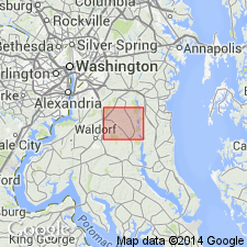
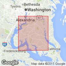
North Keys sand, here named in Prince Georges Co., MD, is a bed of fine yellowish-orange sand that rests conformably on top clay bed of Calvert formation, and in Brandywine area, underlies gravel of Brandywine formation. Sand similar to the North Keys in some places is interbedded with the Brandywine; in others, the Brandywine is separated from the North Keys by sharp, irregular erosional contact. The top of the North Keys is placed at base of lowest gravel in local sequence. Thickness in Brandywine area 20 to 60 ft; maximum thickness in central part of area near Baden. North Keys sand is lithologically unlike Choptank formation as it is exposed in Calvert Cliffs, where it contains sandy clay and clay beds at several horizons. Either North Keys represents an overlap of sandy beds of the Choptank, on eroded Calvert formation or it becomes younger to south and overlaps Choptank as well as Calvert. Unit has been mapped as part of overlying formations and in Brandywine area has been included in Brandywine and Sunderland formations. Age is Miocene(?).
Source: GNU records (USGS DDS-6; Reston GNULEX).
- Usage in publication:
-
- "North Keys Sand"
- Modifications:
-
- Revised
- AAPG geologic province:
-
- Atlantic Coast basin
Summary:
Author believes unit should be stratigraphically reduced as it is in part Choptank Formation.
Source: GNU records (USGS DDS-6; Reston GNULEX).
- Usage in publication:
-
- North Keys
- Modifications:
-
- Not used
- AAPG geologic province:
-
- Atlantic Coast basin
Summary:
North Keys Sand is not used in this report. Author states, "There is no evidence to suggest Hack's 'North Keys Sand' is anything more than weathered Calvert * * * or Choptank."
Source: GNU records (USGS DDS-6; Reston GNULEX).
For more information, please contact Nancy Stamm, Geologic Names Committee Secretary.
Asterisk (*) indicates published by U.S. Geological Survey authors.
"No current usage" (†) implies that a name has been abandoned or has fallen into disuse. Former usage and, if known, replacement name given in parentheses ( ).
Slash (/) indicates name conflicts with nomenclatural guidelines (CSN, 1933; ACSN, 1961, 1970; NACSN, 1983, 2005, 2021). May be explained within brackets ([ ]).