

- Usage in publication:
-
- Nogales Formation*
- Modifications:
-
- Geochronologic dating
- AAPG geologic province:
-
- Basin-and-Range province
Summary:
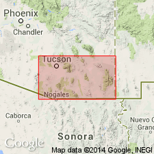
Sample collected from Nogales Formation in the Patagonia Mountains, AZ, Lat. 31 deg. 27 min. N., Long. 110 deg. 03 min. 30 sec. W. Age is considered Miocene. Calculated whole-rock K-Ar age 12.6 +/-0.8 Ma.
Source: Modified from GNU records (USGS DDS-6; Denver GNULEX).
- Usage in publication:
-
- Nogales Formation*
- Modifications:
-
- Named
- Dominant lithology:
-
- Conglomerate
- Sandstone
- Grit
- Basalt
- AAPG geologic province:
-
- Basin-and-Range province
Summary:
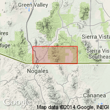
Named for exposures in east and north of town of Nogales, Santa Cruz Co, AZ in Basin-and-Range province. These exposures are designated the type area. Rocks crop out along and south of Sonoita Creek. Total outcrop area in quad is 35-40 sq mi. Rests on and, in part, derived from Oligocene Grosvenor Hills Volcanics. Is overlain by poorly consolidated alluvium believed to be of late Tertiary or Quaternary age. Composed of epiclastic volcanic conglomerate containing abundant beds of sandstone and grit. Divided into lower, middle, and upper members. Thin basalt flows separate middle and upper members. The flow has been dated by K-Ar method as 12.6 +/-0.8 m.y. Has a sedimentary breccia composed of granitic material at base. Is as much as 7,500 ft thick in quad. Assigned a Tertiary age. Geologic map.
Source: GNU records (USGS DDS-6; Denver GNULEX).
- Usage in publication:
-
- Nogales Formation*
- Modifications:
-
- Age modified
- AAPG geologic province:
-
- Basin-and-Range province
Summary:
Age of the Nogales Formation is shown as Miocene and Pliocene on Plate 8.
Source: GNU records (USGS DDS-6; Menlo GNULEX).
For more information, please contact Nancy Stamm, Geologic Names Committee Secretary.
Asterisk (*) indicates published by U.S. Geological Survey authors.
"No current usage" (†) implies that a name has been abandoned or has fallen into disuse. Former usage and, if known, replacement name given in parentheses ( ).
Slash (/) indicates name conflicts with nomenclatural guidelines (CSN, 1933; ACSN, 1961, 1970; NACSN, 1983, 2005, 2021). May be explained within brackets ([ ]).