The National Geologic Map Database is migrating to a new infrastructure. We apologize for any service disruptions during this process.
|
|---|


- Usage in publication:
-
- Niland tongue*
- Modifications:
-
- Original reference
- Dominant lithology:
-
- Coal
- Shale
- Siltstone
- Sandstone
- AAPG geologic province:
-
- Green River basin
Summary:
Pg. 100, 101 (chart), 102. Niland tongue of Wasatch formation. Sequence of coal beds, clay shale, siltstone, sandstone, and low-grade oil shale. In type area, contains four coal zones (ascending) Kelley, Luman, Hay, and Bush. Thickness in type area about 400 feet; thins westward to about 325 feet in Luman Butte area. Underlies Tipton tongue and overlies Luman tongue (new), both of Green River formation, with conformable contacts. Intertongues with Battle Spring formation (new) to north. Age is early Eocene.
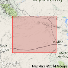
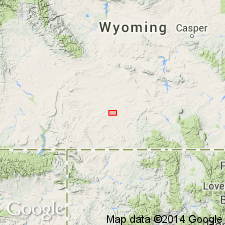
Type area: [Lost Creek Lake area], in SE/4 T. 24 N., R. 96 W., and in SW/4 T. 24 N., R. 95 W., [Lost Creek Lake 15-min quadrangle], Sweetwater Co., southwestern WY. Named from rocks which crop out at southern margin of structural basin called Niland basin and along north side of Lost Creek Flat. Named from Niland Spring in sec. 23, T. 25 N., R. 96 W., [northeastern corner Bush Lake 7.5-min quadrangle, Sweetwater Co., southwestern WY].
Source: US geologic names lexicon (USGS Bull. 1200, p. 2744-2745).
- Usage in publication:
-
- Niland Tongue*
- Modifications:
-
- Age modified
- AAPG geologic province:
-
- Green River basin
Summary:
Age of late early Eocene or Lost Cabin applied to Niland on basis of vertebrate fossils found by McGrew and Roehler. The two authors (1960, Wyoming Geological Association Guidebook, p. 158) found a large fauna--LAMBDOTHERIUM, MENISCOTHERIUM, and HYRACOTHERIUM--a Lost Cabin fauna in sec 8, T18N, R98W, Sweetwater Co, WY in the Greater Green River basin.
Source: GNU records (USGS DDS-6; Denver GNULEX).
- Usage in publication:
-
- Niland Tongue*
- Modifications:
-
- Contact revised
- AAPG geologic province:
-
- Green River basin
Summary:
Lower contact revised in that Niland Tongue of early Eocene age of Wasatch Formation underlies Scheggs Bed (new) of Tipton Shale Member of Green River Formation at the type section of the Scheggs in N1/2 sec 36, T15N, R101W and S1/2 sec 25, T15N, R100 1/2 W, Sweetwater Co, WY in the Greater Green River basin. Basal Scheggs at that locality is a coquinal, crumbly brown oil shale. Stratigraphic diagrams. Rocks assigned to Scheggs in this report were designated lower part of Tipton in earlier reports.
Source: GNU records (USGS DDS-6; Denver GNULEX).
- Usage in publication:
-
- Niland Tongue*
- Modifications:
-
- Areal extent
- Overview
- AAPG geologic province:
-
- Green River basin
Summary:
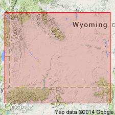
Isopach map showing areal extent within Greater Green River basin, WY and CO. Niland (Wasatch Formation) is 400 ft thick in southeastern part of Green River basin, in southwestern part of Washakie basin, and in western part of Sand Wash basin; thins irregularly from these areas to less than 100 ft in northeastern Washakie and southeastern Great Divide basins and in small areas of southwestern Washakie basin. Stratigraphic chart; cross sections. Eocene age.
Source: GNU records (USGS DDS-6; Denver GNULEX).
- Usage in publication:
-
- Niland Tongue*
- Modifications:
-
- Revised
- AAPG geologic province:
-
- Green River basin
Summary:
Coal bed in upper part of Niland Tongue of Wasatch Formation is informally named Wamsutter Rim coal bed. Study area is along Wamsutter Rim, T19N, R94-95W, Sweetwater Co, WY, Greater Green River basin. Coal is high-quality canneloid coal with an estimated heating value of 11,500 Btu/lb. Coal bed correlates with Vermilion Creek coal bed in southwest part of Washakie basin [southern Greater Green River basin].
Source: GNU records (USGS DDS-6; Denver GNULEX).

- Usage in publication:
-
- Niland Tongue*
- Modifications:
-
- Overview
- AAPG geologic province:
-
- Green River basin
Summary:
Paleogeographic map (fig. 46) of this tongue of Wasatch Formation showing depositional environments in Greater Green River basin. Occupies same geographic area (about 6650 sq mi) as underlying Luman Tongue of Green River Formation though boundaries of depositional environments are different; Niland has nearly same areal extent and depositional environments as Ramsey Ranch Member of Wasatch. Paleogeographic map is at a stratigraphic level in upper part of Niland that represents a large freshwater lake with sand shorelines that was present in eastern part of basin. Swamps surrounded the lake and extensive flood plains surrounded the swamps. Arkosic sediments of Battle Spring Formation were deposited in northeast corner of basin and alluvial fan conglomerates were present along north flank of Uinta Mountains. Underlies Farson Sandstone Member of Green River or Scheggs Bed of Tipton Shale Member of Green River. Generalized stratigraphic correlation chart (fig. 41). Geologic map (fig. 1) of Vermilion Creek area, northwest CO. Eocene age.
Source: GNU records (USGS DDS-6; Denver GNULEX).
For more information, please contact Nancy Stamm, Geologic Names Committee Secretary.
Asterisk (*) indicates published by U.S. Geological Survey authors.
"No current usage" (†) implies that a name has been abandoned or has fallen into disuse. Former usage and, if known, replacement name given in parentheses ( ).
Slash (/) indicates name conflicts with nomenclatural guidelines (CSN, 1933; ACSN, 1961, 1970; NACSN, 1983, 2005, 2021). May be explained within brackets ([ ]).