The National Geologic Map Database is migrating to a new infrastructure. We apologize for any service disruptions during this process.
|
|---|


- Usage in publication:
-
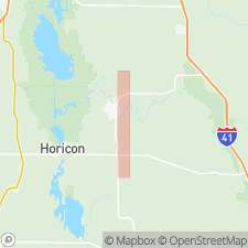
- Neda iron ore
- Modifications:
-
- Named
- Dominant lithology:
-
- Oolite
- Shale
- AAPG geologic province:
-
- Wisconsin arch
Summary:
The iron-ore bed in old ore pit near Neda, WI, heretofore correlated with and called Clinton iron ore, is here named Neda iron ore, because it is now known to be much older than the Clinton of NY. Maquoketa (Richmond) fossils have been found in it. Consists of a hard nonoolitic iron-ore band 0.66 to 1.33 ft thick, underlain by 25 to 32 ft of horizontally and regularly stratified beds of reddish-brown oolitic iron ore, with a thin band of iron-coated fragments of shaly material and iron pebbles near bottom. It unconformably underlies Mayville limestone in ore pit near Neda, and also at Cascade Falls, near Green Bay. At both places it rests unconformably on Maquoketa shale. Occurs in several isolated patches or lenses in southeastern WI. It is "Mayville ore bed" of Chamberlin, but he applied Mayville more definitely to the limestone immediately overlying the ore.
Source: GNU records (USGS DDS-6; Reston GNULEX).
- Usage in publication:
-
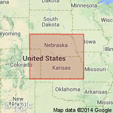
- Neda equivalent
- Modifications:
-
- Overview
- Areal extent
- AAPG geologic province:
-
- Salina basin
Summary:
In southeastern NE and adjacent areas of KS a red shale with oolitic hematite concretions occurs at the top of the Maquoketa and is considered equivalent to the Neda of IA.
Source: GNU records (USGS DDS-6; Reston GNULEX).
- Usage in publication:
-
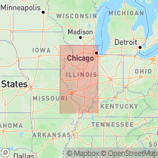
- Neda Formation
- Modifications:
-
- Overview
- AAPG geologic province:
-
- Wisconsin arch
- Illinois basin
- Michigan basin
Summary:
Neda Formation of Maquoketa Group occurs at the Ordovician-Silurian boundary in northern IL and surrounding states. Figure depicts occurrences of Neda as far south as Peoria and Livingston Cos, but the majority are clustered in Lake, Cook, and Dupage Cos, in extreme northeastern IL. Unit is best exposed at its type locality near Neda, Dodge Co., WI. Limited occurrences have been reported elsewhere in WI, northeastern IA, northern IL, IN, and MI. Neda occurs as widespread lenticular bodies of various extent and thickness. Maximum thickness of 16.5 m was reported from subsurface of Manitowoc Co., WI. Unit is generally is much thinner, ranging from 0 to 3.0 m in IL. Formation is lithologically diverse. Basal strata in IL are blackish red hematitic and dolomitic mudstone containing scattered ooids. Lithology in IA is similar. In WI, however, several ft of relatively pure grain-supported goethitic oolite overlie this mudstone. The top of the Neda may be dolomitic siltstone, mudstone, or micrite, oolitic and ferruginous to differing degrees. Goethite is the dominant iron mineral, but hematite is abundant. Siderite is the major iron mineral at one locality. Lower contact with Brainard Shale is most likely unconformable. Upper contact with Kankakee Dolomite is a prominent unconformity. [Though this author credits Gray (1972: IN G.S. Special Report 7) with extension of Neda into IN, GNU records indicate that Gray extended the Maquoketa Group to IN with its Whitewater, Dillsboro, and Kope Formations, but made no mention of the Neda.]
Source: GNU records (USGS DDS-6; Reston GNULEX).
- Usage in publication:
-
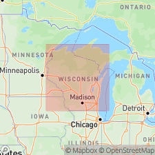
- Neda Formation
- Modifications:
-
- Overview
- Biostratigraphic dating
- Areal extent
- AAPG geologic province:
-
- Wisconsin arch
Summary:
A Late Ordovician (Richmondian) age assignment for the Neda is supported by a new fossil collection from Katells Falls in eastern WI. The Neda is a hematitic oolite, which occurs sporadically, according to these authors, in eastern WI, northern IL, eastern IA, northern IN, and in the subsurface of southern MI, northwestern MO, and southeastern NE. [No documentation given for these areal limits.] These authors state contact with underlying Maquoketa Shale is conformable and gradational.
Source: GNU records (USGS DDS-6; Reston GNULEX).
For more information, please contact Nancy Stamm, Geologic Names Committee Secretary.
Asterisk (*) indicates published by U.S. Geological Survey authors.
"No current usage" (†) implies that a name has been abandoned or has fallen into disuse. Former usage and, if known, replacement name given in parentheses ( ).
Slash (/) indicates name conflicts with nomenclatural guidelines (CSN, 1933; ACSN, 1961, 1970; NACSN, 1983, 2005, 2021). May be explained within brackets ([ ]).